NOAA Awards Lidar Contract
Fugro LADS has been selected by the National Oceanic and Atmospheric Administration (NOAA), USA, to provide Light Detection and Ranging (Lidar) hydrographic survey services to support nautical charting and related...
Fugro LADS has been selected by the National Oceanic and Atmospheric Administration (NOAA), USA, to provide Light Detection and Ranging (Lidar) hydrographic survey services to support nautical charting and related...

RIEGL tested the performance of its topobathymetric airborne laser scanning system in a transition zone context along the French Mediterranean coast. Initially planned as a UAV survey, tests were conducted...
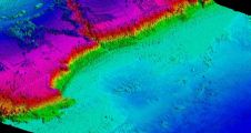
A new bathymetric survey of the Corsican coastline has been commissioned to provide detailed information about ongoing coastal erosion on the Mediterranean island as well as to assess the impact...
Leica Geosystems, part of Hexagon, has announced the introduction of Leica Chiroptera-5, the new high-performance airborne bathymetric Lidar sensor for coastal and inland water surveys. This latest mapping technology increases...
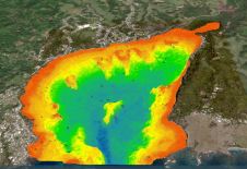
A deep understanding of seabed topography and coastal features is crucial for developing predictive models to address challenges such as coastal inundation and rising sea levels. Communities worldwide rely on...
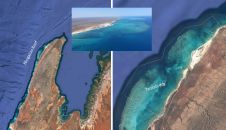
Airborne bathymetric Lidar is an ideal tool to study underwater features in the usually rather clear waters along the coast of Australia. Due to the remoteness of many of the...
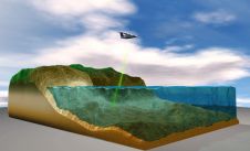
Bathymetric Lidar is the most effective and cost-efficient technology to capture both the land and sea floor simultaneously, in order to provide a continuous, detailed 3D elevation model along the...
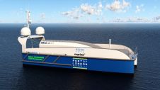
SEA-KIT International has won funding from the Zero Emissions Vessels and Infrastructure (ZEVI) competition to design and manufacture a hydrogen-fuelled uncrewed surface vessel (USV). The company will partner with maritime...
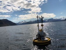
Fugro’s Seawatch Wind Lidar Buoy has achieved the highest commercial maturity rating, Stage 3, in accordance with the Carbon Trust roadmap for the commercial acceptance of floating Lidar technology. Fugro’s...
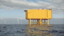
RPS, a leading global professional services firm, has been selected to support a new project to measure wind energy potential and metocean conditions for the Netherlands Enterprise Agency (RVO) at...
This site uses cookies. By continuing to use this website, you agree to our Cookies Policy. Agree