CHC2024
The CHA has a long-standing partnership with The Hydrographic Society of America, and the two organizations take turns hosting this annual international conference series. This year it is Canada’s turn,...
The CHA has a long-standing partnership with The Hydrographic Society of America, and the two organizations take turns hosting this annual international conference series. This year it is Canada’s turn,...
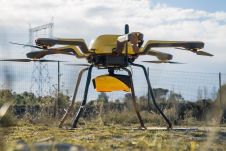
YellowScan, a familiar name in the mapping and land surveying realm, is making a noteworthy entrance in the hydrographic sector with the introduction of its pioneering UAV-based bathymetric Lidar solution....
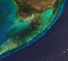
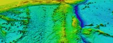
The Florida Department of Environmental Protection has commissioned Woolpert to acquire bathymetric survey data using Lidar technologies to support the Florida Seafloor Mapping Initiative (FSMI) and its mission to produce...
Explore maritime excellence with East Coast Maritime Pty Ltd! As leading marine contractors, our versatile fleet delivers:Port & Channel Maintenance: Expert plough dredging with vessels such as Pacific Conquest and Lismore.Dredging Support: Proven expertise...

Ocean data has a vital but underappreciated role to play as an enabler in shipping’s energy transition. In particular, it can help to unlock the short-term carbon savings that will...
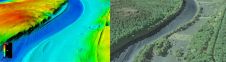
The US Geological Survey (USGS) and Dewberry have jointly released a new topobathymetric Lidar dataset for the Potomac River, extending from the Potomac Highlands in West Virginia to the Chesapeake...

Various attempts have recently been made to expand the scope of research in the maritime field through the convergence of cutting-edge technologies. One example is the remote classification and prediction...
ARGANS, a leading Earth observation company, has contributed a significant dataset of 8,000 square kilometres to The Nippon Foundation-GEBCO Seabed 2030 Project – the project seeking to inspire the complete...
Aspect Land & Hydrographic Surveys Ltd is one of the leading independent coastal survey companies in the UK, with extensive experience and a proven track record in providing high-resolution hydrographic,...
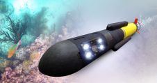
In a collaboration between NOAA’s National Centers for Coastal Ocean Science (NCCOS), AUV manufacturer RTsys and subsea imaging technology manufacturer Arctic Rays, the NemoSens SwordFish has been designed to revolutionize...
This site uses cookies. By continuing to use this website, you agree to our Cookies Policy. Agree