Wave Radars
Radar Remote Sensing of ocean surface waves may in general be defined as measuring characteristics of the sea surface by means of electromagnetic waves so that the sea surface is...
Radar Remote Sensing of ocean surface waves may in general be defined as measuring characteristics of the sea surface by means of electromagnetic waves so that the sea surface is...

One of the fastest emerging trends in hydrographic surveying is the use of the vertical component of RTK GPS to determine real-time water level corrections. There are currently several district...
Who hasn’t heard of the mega projects currently being executed in Dubai? Land reclamation projects that can be seen from space and skyscrapers that reach 800 meters high are not...
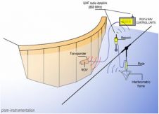
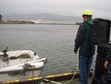
An USBL underwater positioning system is the ideal solution for dam survey by ROV, providing easy and fast set-up and accurate 3D measurement for traceability, but not all USBL systems...
Integral components of a swathe bathymetry system are the motion and heading sensors. The current trend is to offer a system that combines both components in one package, either as...
One of the fastest emerging trends in hydrographic surveying is the use of the vertical component of RTK GPS to determine real-time water level corrections. There are currently several district...
Recent development of a 3-dimensional precise positioning technique by Kinematic GPS (KGPS) makes it possible to realise accurate vertical positioning to several centimetres, even in the sea. But observed vertical...
The inspection and maintenance of vital resource facilities is an integral part of any regional health and stability management programme. Providing consistent quality output whilst reducing inspection and maintenance costs...
RBR Ltd has seen steady growth during the past eight years, especially in oceanography and environmental monitoring instruments. Each of these products has its own interesting story, but the genesis...
Long baseline (LBL) positioning has many applications both commercially and in research, from surveying a ship hull to positioning offshore platforms in deeper waters. The technique consistently provides accuracies in...
This site uses cookies. By continuing to use this website, you agree to our Cookies Policy. Agree