Hydro International - September/October 2020
The cover of this edition of Hydro International shows imagery acquired with the Kongsberg EM 2040P MKII, an advanced shallow water multibeam echosounder. In this issue, you will fi nd...

The cover of this edition of Hydro International shows imagery acquired with the Kongsberg EM 2040P MKII, an advanced shallow water multibeam echosounder. In this issue, you will fi nd...

By providing vessel-to-vessel and vessel-to-shore communication independent of satellite or cellular networks, the Maritime Broadband Radio (MBR) system from Kongsberg introduces possibilities to transform survey operations. Potential applications include delivery...

The 8th International Conference on High Resolution Surveys in Shallow Water is now accepting abstracts for its conference. The event will take place at the Delta Hotel in St. John’s,...
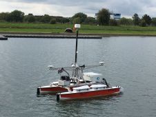
During September 2017, the world’s first autonomous hydrographic survey was performed. 'Autonomous' means not by remote control, but rather that the autonomous surface vehicle (ASV) used guidance from survey software...

Benjamin Busse is a UAV pilot and expert in cartography and geomatics at the Karlsruhe-based Ingenieur Team GEO engineering office.

Dr. Conor Cahalane performs applied research using satellite, airborne and UAV data for coastal mapping and monitoring at the National Centre for Geocomputation (NCG), Maynooth University and the Irish Centre for...
A recent offshore exercise, conducted by Oil Spill Response Ltd. (OSRL, UK), was designed to understand how remote sensing technologies can help detect oil spills at sea more effectively. Utilising...
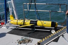
Alongside the autonomous underwater vehicles (AUVs) available for mine countermeasures (MCM), the Kongsberg stand (C40) at Underwater Defence Technology (UDT 2017) in Bremen, Germany, will host Kongsberg Maritime’s compact acoustics...

4D Ocean was launched on the 3 April 2017 to provide autonomous survey services to the seabed mapping community. As a dedicated ASV, AUV and UAV operator they can supply...
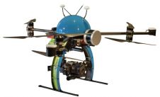
The NEXUS 800 powered by HYPACK is a full end-to-end solution representing a new paradigm in unmanned aerial vehicle (UAV) data collection by harmonising Lidar data with photogrammetry. The NEXUS...
This site uses cookies. By continuing to use this website, you agree to our Cookies Policy. Agree