NEXUS 800 Powered by HYPACK on Display
The NEXUS 800 powered by HYPACK is a full end-to-end solution representing a new paradigm in unmanned aerial vehicle (UAV) data collection by harmonising Lidar data with photogrammetry. The NEXUS...
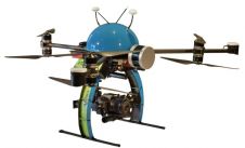
The NEXUS 800 powered by HYPACK is a full end-to-end solution representing a new paradigm in unmanned aerial vehicle (UAV) data collection by harmonising Lidar data with photogrammetry. The NEXUS...
SBG Systems has taken a major step in the surveying industry by unveiling Qinertia, its in-house post-processing software, at the Ocean Business show (UK). After the survey, this full-feature software...
The Open Geospatial Consortium (OGC) seeks comments on the draft charter of a proposed Unmanned Systems Domain Working Group (UXS DWG). The proposed DWG will provide an open forum for...
A NEXUS 800 UAS powered by HYPACK has been provided to the US southeastern geospatial solutions company SurvTech. The company will use the device to acquire upland data simultaneous with...

The bi-annual event Ocean Business is coming to the NOC, Southampton from 4-6 April 2017. Three days of ocean technology engineering and science, knowledge sharing, hands-on training and demos as...
RIEGL traditionally uses the Intergeo platform to give an insight into and an overview of its comprehensive Lidar sensors and systems product range. At booth C3.059 in hall A3, on...

High Precision, Long-Range UAV Lidar & Drone Lidar Mapping Solutions At YellowScan, we design, develop and build Lidar solutions for professionals that require performance, robustness and accuracy. Our hardware and...
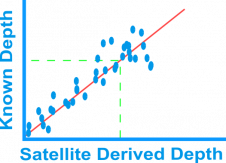
Bathymetry is traditionally acquired using singlebeam or multibeam echosounders. This method produces accurate depth measurements along transects but is constrained by operating cost and an inability to survey in very...
Applanix has introduced POSPac MMS 8 GNSS-aided inertial post-processing software for georeferencing data collected from cameras, Lidars, multibeam sonar and other sensors on mobile platforms. The announcement was made on...
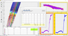
Discussing and comparing software has often been tricky in Hydro International as it is difficult to put the packages together and see clear differences. In this overview of hydrographic processing software,...
This site uses cookies. By continuing to use this website, you agree to our Cookies Policy. Agree