Bourbon Offshore Norway Chooses C-MAP
The offshore Anchor Handling Tug Supply (AHTS) vessel Bourbon Orca, which recently won the 'Ship of the Year 2006' award, is just one of the vessels in the Bourbon Offshore...
The offshore Anchor Handling Tug Supply (AHTS) vessel Bourbon Orca, which recently won the 'Ship of the Year 2006' award, is just one of the vessels in the Bourbon Offshore...
Northrop Grumman has received type approval from the U.K. certification body QinetiQ for its new-generation marine radar systems. The QinetiQ type approval certifies that the new Sperry Marine VisionMaster FT...
GPS/Acoustic Seafloor geodetic observation technique has made notable progress over recent years. Positional precision better than several centimetres has been attained through tremendous efforts to improve accuracy in both software...
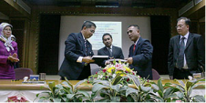
A B$9.5 million project for the delivery of Brunei's national Spatial Data Infrastructure (NSDI) was officially contracted end of April 2007 during a signing ceremony between the Ministry of Development...
Safe Software’s FME 2007 includes Spatial ETL capability for raster data from now on. The new version provides raster and vector integration capability and facilitates GIS professionals to work with...
World Hydrography Day provides an opportunity for the goals and objectives of the International Hydrographic Organization (IHO) to be brought to the attention of a wider audience than is usually...
A growing problem exists with forward-deployed electronic chart display and information systems (ECDIS) in obtaining and updating geospatial data(electronic nautical charts). This problem is commonly referred to as distributing geospatial...
The availability of various sensors and sophisticated technology providing digital data means that today’s hydrographers must attune to the idea that the final products should be available in a hydrographic...
Google Earth and its related layer language Keyhole Markup Language (KML) have taken the mapping world by storm. Combining an approachable user interface, high-quality satellite imagery, and free cost (for...
When a hurricane, a tsunami, or other disaster occurs, one of the first and most critical challenges facing effective disaster response is rapid access to accurate spatial data. Safe Software...
This site uses cookies. By continuing to use this website, you agree to our Cookies Policy. Agree