Dredging Point-cloud Software
Charting underwater structures, soils and project progression using GPS, sonar, single and multibeam systems produces a huge amount of data that needs to be analysed. Vast project areas can be...
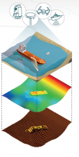
Charting underwater structures, soils and project progression using GPS, sonar, single and multibeam systems produces a huge amount of data that needs to be analysed. Vast project areas can be...
The United Kingdom Hydrographic Office (UKHO) Admiralty Information Overlay (AIO) is available on Danelec Marine DM800 G2 Electronic Chart Display and Information Systems (ECDIS). AIO allows subscribers using the Admiralty...
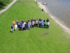
Twenty 3rd-year students of ocean technology from the Maritime Institute Willem Barentsz (MIWB, The Netherlands) participated in the 4th edition of the Lake Survey. Building on last year’s experience and...
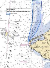
TerraSond, a hydrographic services company based in Palmer, Alaska (USA), utilised an unmanned Autonomous Surface Vessel (ASV) to assist with the acquisition of survey data in July of 2015 in...
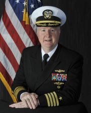
In October 2015, Capt Brian D. Connon assumed the role of director of the National Geospatial-Intelligence Agency’s Maritime Safety Office. The organisation is an important, although not always visible, link in...

Invasive alien species are now generally recognised as one of the greatest threats to biodiversity globally, they present serious economic, environmental and health impacts and, as a result, place major...
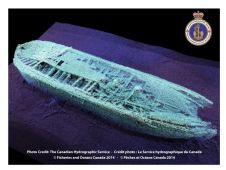
“We know where the target is not located” is the only guaranteed result of any search expedition. This statement does not make for exciting headlines, however, the value of knowledge...

An easier user interface, improved docking mode and advanced sensor handling have been developed to improve the ORCA Pilot G2 Portable Pilot Unit application in its second version. Significant changes...
The United Kingdom Hydrographic Office (UKHO) has worked closely with Kongsberg Maritime to ensure the latest K-Bridge ECDIS and K-Nav ECDIS software includes Admiralty Information Overlay (AIO), making additional chart...

Hydro International traditionally prepares a preview of Oceanology International to help you prepare for the highlights of what businesses on the show floor will be presenting. The Hydro International preview offers you...
This site uses cookies. By continuing to use this website, you agree to our Cookies Policy. Agree