Vessel Motion Monitoring Systems for Wind Farms
OSIL, UK, has announced the launch of a Vessel Motion Monitoring System (VMMS), a system designed to monitor motion of a vessel in order to increase safety of transfers during...
OSIL, UK, has announced the launch of a Vessel Motion Monitoring System (VMMS), a system designed to monitor motion of a vessel in order to increase safety of transfers during...

Xsens , headquartered in Enschede, the Netherlands, with a subsidiary in Los Angeles, USA, is the leading innovator in 3D motion tracking technology and products, based on MEMS sensors and...
Scientists from the Habitat Research Group (HRG) are conducting studies to identify the essential habitats of eastern Bering Sea species. This includes work to identify suitable predictor variables for quantitative...
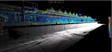
The Miami Port and Terminal Technology USA 2012 4th international conference and exhibition saw the launch of the industry's first custom-designed 4D (x,y,z + time) land and marine survey vessel....
Germanischer Lloyd (GL) Renewables Certification (GL RC, Germany) is to certify Kawasaki Heavy Industries' (KHI) tidal energy converter prototype. The certification will be carried out according to GL RC's Guideline...
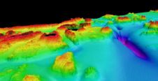
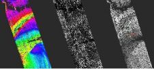
Designing offshore engineering facilities requires large amounts of information. To acquire it, suites of engineering and geophysical surveys are run, which as a rule include such techniques of seabed and...
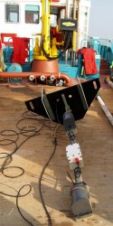
MMT Group has purchased and installed a Kongsberg EM2040D dual head multi-beam echo sounder on its survey and ROV vessel IceBeam. By operating an EM 2040 dual head, MMT is...
Sagem (Safran Group) is to integrate Xsens' sensor fusion signal processing modules in a new line of inertial navigation system products. As part of the supply agreement, Xsens has customised...
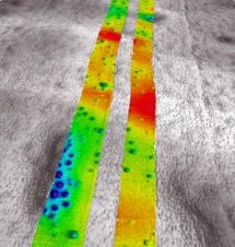
Burying utility cables under the seabed in shallow water environments to ensure cable safety is accelerating because of green power generation initiatives and the relative ease of securing permits to...
Airborne Lidar (Light Detecting and Ranging) is a well-established remote sensing technique which scans the terrain and seafloor with high-frequency laser pulses. Until now, bathymetric Lidar data has been processed...
This site uses cookies. By continuing to use this website, you agree to our Cookies Policy. Agree