Jason Errey
Jason has over 15 years of experience in the Environmental and Oceanographic industry including extensive experience in managerial roles in Australia and the Middle East, and a Masters specialising in...

Jason has over 15 years of experience in the Environmental and Oceanographic industry including extensive experience in managerial roles in Australia and the Middle East, and a Masters specialising in...
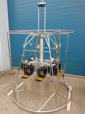
International seabed sampling specialist Ocean Scientific International (OSIL) has shipped a uniquely modified version of the industry-standard multiple corer to Australia for use in a project in a remote location...

In September 2017, NOAA’s Integrated Ocean and Coastal Mapping Programme completed a multi-year ocean mapping project off the coast of Washington in Olympic Coast National Marine Sanctuary. This project grew out of a seafloor...

UK marine survey company Partrac Ltd recently provided key seabed erosion data to the Scottish Association for Marine Science (SAMS), for a project funded by the Scottish Government since 2013,...

MMT has been awarded a contract by the Danish energy transmission system operator Energinet as part of the Baltic Pipe project. The assignment includes a route survey for a new...
Aquatec Group has expanded the 'Sediment? Solved' range to include instrumentation to measure surface sediment stability, with the addition of Partrac’s benthic flumes and Cohesive Strength Meter (CSM). The Cohesive...

Veerle Huvenne is a Marine Geoscientist from the National Oceanography Centre, Southampton, UK. She has more than 15 years of experience in benthic habitat mapping. She has participated in 30 international scientific...
The IOGP Geomatics Committee’s Seabed Survey Data Model (SSDM) Task Force has completed SSDM version 2 incorporating industry feedback received since the release of SSDM version 1 in April 2011....
Fugro has completed a seabed survey for the Viking Link, one of the longest DC electricity interconnectors that will link the UK and Danish electricity supplies. Awarded in February 2016,...

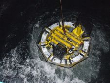
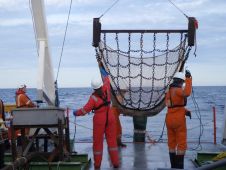
Geoscience Australia's Antarctic Geoscience programme has completed three highly successful Antarctic surveys during the 2016-17 field season. Marine geoscience and geophysical data acquisition surveys are important for learning about these...
This site uses cookies. By continuing to use this website, you agree to our Cookies Policy. Agree