Introducing the Denmark Depth Model
The Denmark Depth Model (DDM) is a digital bathymetric model covering Denmark’s exclusive economic zone (EEZ). It was developed based on hundreds of bathymetric survey datasets and historical sources and...
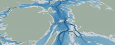
The Denmark Depth Model (DDM) is a digital bathymetric model covering Denmark’s exclusive economic zone (EEZ). It was developed based on hundreds of bathymetric survey datasets and historical sources and...
TCarta Marine, a global provider of hydrospatial products and services, is expanding its involvement in the Seabed 2030 project. The initiative aims to map the entire ocean floor by 2030,...
As a leading manufacturer of hydrographic and oceanographic instruments, the technology of Valeport is used for a wide variety of purposes, which includes gathering critical data about our coastal environments....
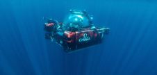
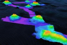
The Tonga Eruption Seabed Mapping Project (TESMaP) is a collaborative mission to discover the undersea impacts of the January 2022 eruption of the Hunga-Tonga Hunga-Ha’apai volcano. Using their collective knowledge,...
Oxford University researchers are playing a key role in the first systematic survey of ocean life in the Maldives, from the surface to 1,000 metres deep. This will enable the...

Carolyn Geraghty is the restoration programme manager for the Morro Bay NEP, where she develops and oversees watershed and estuarine restoration projects and conservation efforts. She has a Master’s degree...
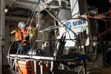
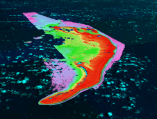
New findings from the record-breaking Tongan volcanic eruption are “surprising and unexpected” say scientists from New Zealand’s National Institute for Water and Atmospheric Research (NIWA). NIWA’s research vessel, RV Tangaroa,...

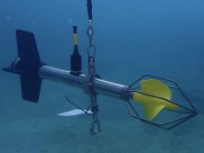
A prototype of the AZFP6-ice was deployed in the coastal waters approximately 40km east of the town of Nain, Labrador (Canada), an area used for Indigenous traditional hunting and fishing....
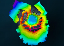
Between 20 June and 29 July 2021, NOAA Ocean Exploration, in partnership with USGS, the U.S. Fish and Wildlife Service (USFWS), and other organizations and universities, conducted a telepresence-enabled ocean exploration to...

Mathias Jonas, Secretary-General, IHO, describes the implications of the UN Decade of Ocean Science for Sustainable Development for the IHO and the hydrography sector. Proclaimed in 2017 by the United...
This site uses cookies. By continuing to use this website, you agree to our Cookies Policy. Agree