Introducing the Denmark Depth Model
A closer look at a new bathymetric model covering Denmark’s EEZ
The Denmark Depth Model (DDM) is a digital bathymetric model covering Denmark’s exclusive economic zone (EEZ). It was developed based on hundreds of bathymetric survey datasets and historical sources and is the first model released by the Danish Geodata Agency to cover Danish waters with a grid resolution of 50 metres. In light of increasing environmental concerns, the DDM makes a significant contribution to the United Nations Sustainable Development Goal 14, which aims to “conserve and sustainably use the oceans, seas and marine resources for sustainable development.”
The public availability of several digital bathymetric models (DBMs) may give the false impression that the seafloor bathymetry of the oceans is largely known at full coverage. This impression is however easily disproved by evaluating the content of these models. For instance, the General Bathymetric Chart of the Oceans (GEBCO) lacks actual depth measurements for the majority of its coverage. Although such models incorporate data from both single-beam echosounders (SBES) and modern high-resolution multibeam echosounders (MBES), they largely rely on interpolation and altimetry-derived data.
Furthermore, for model depths based on actual measurements, the density and accuracy of the soundings (bathymetric measurements) vary widely, which heavily impacts the reliability of the estimated depths. Historical depths are mostly derived from lead-lines, and are therefore sparse and obtained from a minimal seafloor area (i.e. the few-centimetres diameter of the used weight). Compared to lead-lines, SBES provides denser depth measurements. However, although the position of the measured depth is assumed to be at the nadir of the surveying platform, its actual location could be anywhere in the ensonified area. Unquestionably, a modern MBES provides a higher density and resolution than lead-lines and SBES. Unfortunately, however, the collection of high-resolution bathymetry is not only expensive and frequently challenging, but also time-consuming as it is only able to cover relatively small regions at one time.
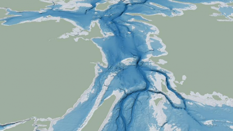
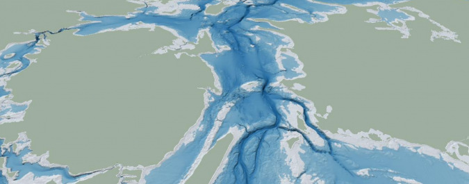
The adoption of advanced techniques to improve the compilation of the available sparse soundings into a DBM has proven beneficial to many fields, such as geophysics, geology, biology and oceanography. The current poor knowledge of the ocean seafloor represents a limitation to our understanding of critical ocean processes that provide resources and goods for humanity, controlling the climate and more generally sustaining life on Earth. Contributing to overcome this limitation is in line with the United Nations Sustainable Development Goal 14 and represents the main motivation for the creation of the DDM (Fig. 1).
Data management and model creation
Starting in early 2020, the Danish Geodata Agency attempted to organize available bathymetric datasets in Danish and Greenlandic waters into a modern geospatial data management system named DYBDB, and developed elaborate methodologies to compile these data sources into DBMs and other valuable products (e.g. hydrographic survey overviews). The DDM represents the first released bathymetric product created employing DYBDB. By improving the bathymetric coverage in the Danish EEZ, which is currently provided by EMODnet Bathymetry, one of the major motivations for the creation of the DDM was to support environmental studies and other research efforts in the North Sea and the Baltic Sea.
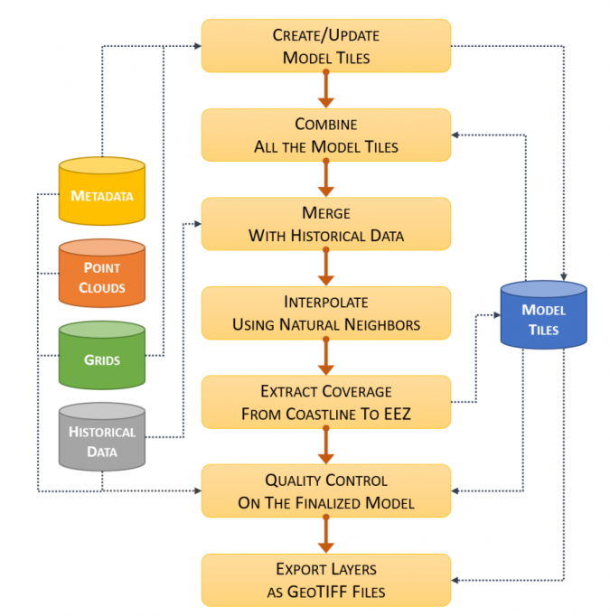
During the processes of model creation and validation, DYBDB provides access to datasets – metadata, point clouds and bathymetric grids – as well as storage for the intermediate products and the finalized model. The overall compilation approach is described in Figure 2. The mechanism for compiling the hundreds of sources reduces the computation time by updating only the model tiles affected by data changes. More generally, the creation of a robust workflow facilitates the integration of new data sources in the DBM while preserving consistency in the presentation of the finalized product. Future work will explore automated procedures to improve the efficiency of the current quality control of the finalized DBM.
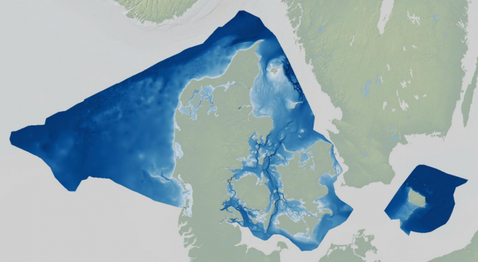
The latest EMODnet Bathymetry DTM (released in December 2020) has a grid resolution of 1/16 arc minutes (about 115m). As such, to improve the resolution of the publicly available bathymetry within Denmark’s EEZ, the DDM aimed for a regularly spaced grid resolution of 50 metres. This was judged to represent a reasonable trade-off between areas covered by high-resolution surveys (e.g. in the Kattegat area) and regions with sparse historical soundings (e.g. a large part of the North Sea).
First release
Official publication of the first release of the DDM took place on 1 November 2022. The downloading services are available on the Danish Geodata Agency website. The DDM is also available in OGC web services (i.e. Web Map Service).
The released bathymetric layer covers an area of 232,679km2, and most (~97.5%) of the cells are less than 100m deep. Based on the auxiliary source layer, 18% of the populated grid cells are derived from MBES surveys and about 75% from interpolation. The large variability in data density based on the types and years determined areas in the model with detailed bathymetry derived from MBES surveys and others that were heavily smoothed (because of the interpolation between sparse soundings).
The DDM is generated using an averaging approach, and is therefore not targeted for safety of navigation. However, several of the steps described in the compilation workflow can be re-used for future works targeting the development of a navigation surface to streamline the production of nautical charts.
The adopted interpolation approach based on the Natural Neighbor algorithm shows positive results in preserving the details of the areas with dense MBES data, as well as in transitioning between areas of wildly different density. However, future work may involve exploring alternative interpolation approaches for introducing further improvements in the DDM. Future releases of the DDM are also likely to include additional data to reduce the interpolated areas, extend the coverage of the inner waters (i.e. fjords, rivers and lakes) and reduce all the depth values to a common vertical datum (e.g. mean sea level).
Significantly increasing the percentage of high-density data in the coming years will be resource-intensive, also because the acoustic swath of MBES is limited by the relatively shallow depths surrounding Denmark. This consideration is one of the main drivers for exploring alternative data sources, such as bathymetric Lidar and satellite-derived bathymetry – both limited to shallow waters in coastal areas – and crowdsourced bathymetry (CSB).
Several aspects of marine geosciences, such as seafloor characterization, sedimentary studies or offshore engineering, require a high-quality bathymetric model like the DDM. The metadata and documentation associated with the DDM aim to facilitate its discovery by researchers when searching for the bathymetry best fitting their specific purposes. The original datasets, which are not distributed with the model, are described in the auxiliary layers to provide clear information about the bathymetric sources locally in use by the DBM.
Facilitating access to marine data is a critical component of the EU Marine Strategy Framework Directive and the EU Marine Knowledge 2020 agenda, including the EMODnet initiative. The released DDM is also a data source for the coming release of EMODnet Bathymetry.
Conclusions
The DDM was created from hundreds of modern datasets (described in the auxiliary layers), historical sources and interpolation. The resulting model represents the first publicly released model covering the Danish EEZ at a resolution of 50 metres.
The DDM significantly improves the bathymetric coverage in the Denmark’s EEZ compared to that provided by EMODnet Bathymetry. As such, and in times of increasing environmental concerns, the DDM provides a relevant contribution to conserve and sustainably use the oceans, seas and marine resources for sustainable development, as described in the United Nations Sustainable Development Goal 14.
More information:
- https://eng.gst.dk/about-us/news-archive/2022/explore-the-depths
- https://www.mdpi.com/2673-7418/2/4/26
Multimedia:

Value staying current with hydrography?
Stay on the map with our expertly curated newsletters.
We provide educational insights, industry updates, and inspiring stories from the world of hydrography to help you learn, grow, and navigate your field with confidence. Don't miss out - subscribe today and ensure you're always informed, educated, and inspired by the latest in hydrographic technology and research.
Choose your newsletter(s)


