Dreaming away...
A sunny day with some dark clouds in the sky – a typical day in June at the Dutch estuary. I have just finished my exams and am sitting on...
A sunny day with some dark clouds in the sky – a typical day in June at the Dutch estuary. I have just finished my exams and am sitting on...
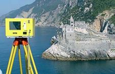
When surveying the coastline, the integration of bathymetric (below sea level) and laser scanning (above sea level) data causes problems due to the different imaging properties. However, by ensuring that...
NASA begins a series of flights 15th October to study changes to Antarctica's sea ice, glaciers and ice sheets. The flights are part of Operation Ice Bridge, a six-year campaign...
This is the continuation of the Oceanology International Preview. For companies A - L, see part 1 MacArtney Underwater Technology Group MacArtney will be introducing their newest innovation in multiplexers...
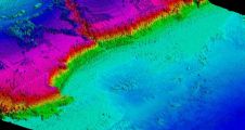
A new bathymetric survey of the Corsican coastline has been commissioned to provide detailed information about ongoing coastal erosion on the Mediterranean island as well as to assess the impact...
IVS 3D announced its partnership with Geomatics Data Solutions to provide sales, support, and training to Fledermaus clients located on the western coast of North America. With over 25 years...
Amongst the largest contracted coastal hydrographic Lidar survey projects awarded in recent years is the Australian Hydrographic Service (AHS) survey of the Torres Strait in Northern Queensland. The intent of...
NASA's Operation IceBridge mission, the largest airborne survey ever flown of Earth's polar ice, kicks off its second year of study when NASA aircraft arrive in Greenland 22nd March. The...
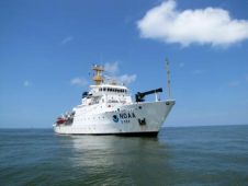
NOAA Ship Thomas Jefferson returned to Galveston, Texas, USA on 11th June from an eight-day research mission to investigate the presence and distribution of sub-surface oil from the Deepwater Horizon/BP...
On 6 July 2010, Hexagon AB entered into an agreement to acquire US-based software provider Intergraph Corporation. The transaction, at a value of USD2,125 million, is financed on cash basis....
This site uses cookies. By continuing to use this website, you agree to our Cookies Policy. Agree