Robotic Glider to Map Moreton Bay Impacts
An AUD200,000 CSIRO coastal glider is bound for Queensland, Australia, to be deployed in Moreton Bay to investigate the impact of the recent flooding on marine ecosystems. Dr Andy Steven...
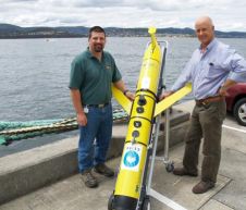
An AUD200,000 CSIRO coastal glider is bound for Queensland, Australia, to be deployed in Moreton Bay to investigate the impact of the recent flooding on marine ecosystems. Dr Andy Steven...
Researchers and flight crew arrived in Thule, Greenland, on Monday 14th March for the start of NASA's 2011 Operation IceBridge, an airborne mission to study changes in Arctic polar ice....

Newton Labs has developed and deployed a laser scanning product specifically designed to operate underwater, in-vessel, within either PWR or BWR reactors. The device, the NM200UW Nuclear Underwater Laser Scanner,...
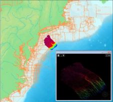
The latest release Bathy DataBASE 3.1 from CARIS now works with Oracle Spatial 11g, utilising the GeoRaster and geo point-cloud data structures for storage. Oracle Spatial has been specifically designed...
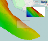
The latest release of Spatial Fusion Enterprise builds on its support of Open Geospatial Consortium (OGC) standards by implementing the Web Coverage Service (WCS) standard for bathymetric data. The new...

Researchers at the University of Illinois (US) have become the first to record an airglow signature in the upper atmosphere produced by a tsunami using a camera system based in...
iXSurvey has recently purchased LizardTech’s GeoExpress software. The company acquires hydrographic and geophysical data which is crucial for both offshore and coastal engineering projects. GeoExpress is now being used to...

OceanServer Technology (USA) will be launching several new technologies at the Undersea Defense Technology conference held at the London ExCel Centre, UK, from 7th to 9th June 2011. OceanServer has...

NASA-funded researchers have created the first complete map of the speed and direction of ice flow in Antarctica. The map, which shows glaciers flowing thousands of miles from the continent's...

Satellite measurements indicate that there will once again be a below-average ice cover in the Arctic this year. As sea ice has melted during the summer months, two major shipping...
This site uses cookies. By continuing to use this website, you agree to our Cookies Policy. Agree