Cartography at the Source
For two decades, CARIS’ hydrographic production database solution has enabled geospatial data to be managed in a data centric manner, while allowing various types of products to be created and...
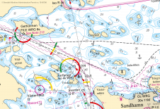
For two decades, CARIS’ hydrographic production database solution has enabled geospatial data to be managed in a data centric manner, while allowing various types of products to be created and...

Teledyne CARIS has announced they will be delivering a full software solution to the South African Navy Hydrographic Office. The solution, provided through Teledyne CARIS’ official distributor Unique Group, includes...
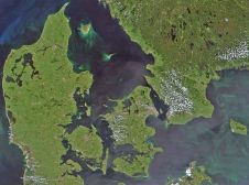
Esri, a location intelligence company, has announced that it has partnered with the Danish Geodata Agency (GST) to implement a modern workflow to more efficiently create and maintain nautical charts...
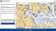
NOAA has released ASSIST, a system for submitting questions and reporting nautical chart errors to NOAA's Office of Coast Survey. ASSIST has a mobile-friendly design and improved user interface that...
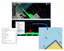
Teledyne CARIS has released of Bathy DataBASE 5.2, which introduces enhanced tools for validating and creating chart features from lidar surveys as well as new bathymetry compilation techniques. This version...
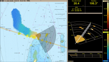
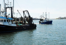
FarSounder is the most recent company to join the International Hydrographic Organization’s Crowd-Sourced Bathymetry (CSB) initiative by becoming a “trusted node” with the NOAA. This project enables mariners to voluntarily...
Airbus Defence and Space has announced that the entire edited WorldDEM database, together with the already available WorldDEM4Ortho dataset, is now available via streaming.This online access to the WorldDEM and...
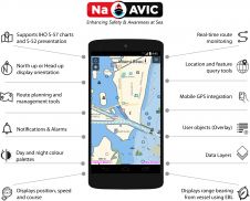
NaAVIC is a free and downloadable electronic voyage application that goes beyond the traditional Electronic Chart System (ECS) app whereby the data, including the ENC information, does not physically reside...
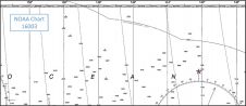
NOAA’s Marine Chart Division (MCD) is currently revising production efforts using an ‘ENC-first’ approach to provide seamless and tiled geographic coverage. Currently, ENC production workflows within MCD require cartographers to...
Earlier this year, NOAA announced the end of a testing phase for the development of a new crowdsourced bathymetry database. The public can now access the bathymetric observations and measurements...
This site uses cookies. By continuing to use this website, you agree to our Cookies Policy. Agree