Friedhelm Moggert-Kägeler
Friedhelm Moggert-Kägeler has an educational background in Geodesy/Hydrography and holds a degree in both fields. He joined SevenCs in 2000 and he has worked in various positions ever since. His...
Friedhelm Moggert-Kägeler has an educational background in Geodesy/Hydrography and holds a degree in both fields. He joined SevenCs in 2000 and he has worked in various positions ever since. His...
Kristiyan Panayotov is a land survey engineer who graduated from the University of Architecture, Civil Engineering and Geodesy in Sofia, Bulgaria. He also studied Cartography and Topography at Universidad Politécnica...

Prof. Dr.-Ing. Harald Sternberg was trained as a surveyor by the German Army (Bundeswehr). He did his doctorate on surveying in 2001 and has been lecturing Geodesy and Hydrography at...
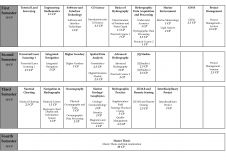
A hydrographic education programme has been offered in Hamburg for more than 30 years. The programme was first offered in 1985 as an addition to an existing programme in general...
The key to the success of any project lies in thorough preparation, and hydrographic surveys are no exception. In this article, Vitad Pradith from Teledyne Oceanscience provides five tips to...
Gottfried Mandlburger studied geodesy at TU Wien, where he also obtained his Ph.D. in 2006. After finishing a 3-years research stay at the University of Stuttgart (2017-2019), he returned to...
has been head of the Bathymetry and Geodesy Group at AWI Bremerhaven since 1983 and responsible for the AWI bathymetric mapping programmes in Artic and Antarctic waters. As chief scientist,...

The disappearance of Malaysian Airlines flight MH370 on 8 March 2014 led to a deep ocean search effort of unprecedented scale and detail in the remote south-eastern Indian Ocean. Between...
Pim Kuus is a Hydrographic specialist and site engineering manager at Teledyne RESON UK Ltd, in Aberdeen. He holds an MScEng in Geodesy and Geomatics Engineering from the University of...
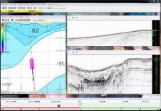
Hypack is pleased to announce the release of our new Hypack Sub-bottom Profiling Software. The package has a comprehensive global geodesy model and a simplified hardware setup with the ability...
This site uses cookies. By continuing to use this website, you agree to our Cookies Policy. Agree