Agnieszka Kubowicz
Agnieszka Kubowicz holds a PhD degree in Earth Sciences. She has been an adjunct at the Institute of Oceanography, University of Gdańsk, since 2012. Her main research interests include coastal...

Agnieszka Kubowicz holds a PhD degree in Earth Sciences. She has been an adjunct at the Institute of Oceanography, University of Gdańsk, since 2012. Her main research interests include coastal...

Łukasz Janowski holds a PhD in Earth Sciences. He has been an adjunct at the Maritime Institute, Gdynia Maritime University, since 2019 and has authored several articles and conference proceedings....
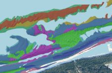
This article presents a novel methodological approach to understand and assess the suitability of airborne Lidar bathymetry for the automatic classification and mapping of the seabed. This solution allows recording of...
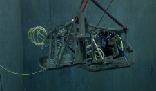
In a bid to uncover the secrets of the deep seafloor, the Monterey Bay Aquarium Research Institute (MBARI) has joined forces with 3D at Depth, a leading expert in commercial...

Maria Geraga is professor of Archaeological Oceanography at the Geology department of the University of Patras and a member of the Laboratory of Marine Geology and Physical Oceanography. Her research...

George Papatheodorou is professor of Geological and Environmental Oceanography at the Geology department of the University of Patras, Greece, and director of the Laboratory of Marine Geology and Physical Oceanography....
Maria Papakonstantinou is a research associate at the Laboratory of Marine Geology and Physical Oceanography in the Geology department of the University of Patras. She holds an MSc in Oceanography...

Dr Elias Fakiris is a research associate at the Laboratory of Marine Geology and Physical Oceanography in the Geology department of the University of Patras. He has multidisciplinary scientific experience,...
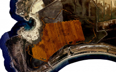
Unmanned surface vehicles (USVs) are increasingly being used for the mapping and management of shallow-water environments such as lagoons, rivers and estuaries, due to their economic and ecological benefits. The...
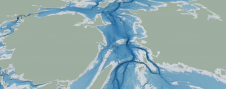
The Denmark Depth Model (DDM) is a digital bathymetric model covering Denmark’s exclusive economic zone (EEZ). It was developed based on hundreds of bathymetric survey datasets and historical sources and...
This site uses cookies. By continuing to use this website, you agree to our Cookies Policy. Agree