LANDMark Mobile Mapping
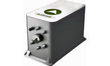
Applanix introduced today the latest LANDMark Marine mobile mapping solution, which enables the creation of seamless models of near shore environments by providing a georeferenced point cloud which integrates with...
Applanix introduced today the latest LANDMark Marine mobile mapping solution, which enables the creation of seamless models of near shore environments by providing a georeferenced point cloud which integrates with...
IXSEA is broadening its range with the launch of a Land and Air Division at INTERGEO, this week. The new division delivers georeferencing systems for the airborne and land-based survey...
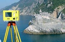
When surveying the coastline, the integration of bathymetric (below sea level) and laser scanning (above sea level) data causes problems due to the different imaging properties. However, by ensuring that...
Tenders are invited for miscellaneous services in Italy. Italy - Tenders are invited for miscellaneous services Bidding Type International Competitive Bidding Financier - Self-Funded Country Italy Description Tenders are invited...
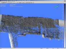
Laser scanning and bathymetric side-scan sonar represent the cutting edge of environmental survey technology. Over the last few years, we have tested the integration of these two methodologies, carrying out...

During a habitat mapping project at the Cyclades Islands (southern Aegean Sea - eastern Mediterranean Sea) which focused on the mapping of coralline algae, the shipwreck of HMHS Britannic was...
Applanix has released version 4.3 if its airborne data post-processing software POSPac AIR, incorporating a series of application-specific tools for systems using the company’s direct georeferencing technology POS AV (Position...
Since GPS found its way into positioning, differential processing has beentheway to high precision. Technological advances and large-scale international collaboration have now made it possible to get sub-decimetre accuracy (95%,...
Applanix presents in its booth (C1-1537) Position and Orientation Systems (POS) for airborne, land, and marine surveying. Applanix will also introduce visitors to the latest POSTrack Flight Management System technology...
The French Hydrographic Office (SHOM) uses remotely sensed visible imagery for the cartography of atolls and reefs. It is considered as an efficient and relatively inexpensive method to collect information...
This site uses cookies. By continuing to use this website, you agree to our Cookies Policy. Agree