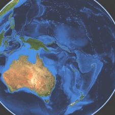
Found 552 results
Sort by

Hydro International #4- 2022

The analysis, distribution and visualization of geospatial data are all vital steps in mapping and surveying workflows The analysis, distribution and visualization of geospatial data are all vital steps in mapping and surveying workflows. The resulting geodata is a key driver of today’s information society, used for...

Read more

Think Big for Coastal Mapping

“Think big for coastal mapping” is the foremost advice that Don Ventura of Teledyne Geospatial would impress upon agencies interested in bathymetric Lidar. “It’s a matter of efficiency of scale.”...

Read more

Steve Raber

Steve Raber is senior programme manager for NV5 Geospatial, where he is responsible for business development within the federal-civil government sector and the management of several large contracts, from his...

Read more