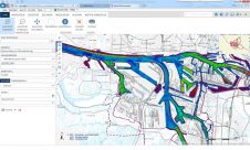
Centralised Data for Hamburg Port Authority
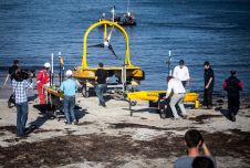
The Port of Hamburg is the third-largest container port in Europe and among the biggest in the world. There are almost 300 berths with a total of 43 kilometres of quay servicing...
The Port of Hamburg is the third-largest container port in Europe and among the biggest in the world. There are almost 300 berths with a total of 43 kilometres of quay servicing...
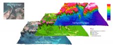
The European Marine Observation and Data Network (EMODnet) Phase 3 High Resolution Seabed Mapping Project has been awarded to a consortium headed by the French Hydrographic Office (SHOM) and Maris...
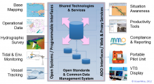
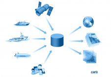
Ports require access to a wide range of data and information to function safely and efficiently. Some of that data is acquired from external stakeholders but most is generated internally...
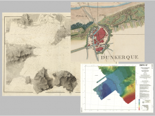
In 2016, as part of the ARCHIPEL project (ARCHIves Patrimoniales En Ligne), Shom digitised 10,000 cartographic documents from all over the world and from its historical maritime and coastal archives....
A recent article provides an overview of satellite-derived bathymetry methods and how data can be integrated into survey campaigns, and showcases three use cases. Bathymetric data in shallow-water zones is...
It’s often a cliché to say that everything offshore has changed since the introduction of GPS, but there have certainly been many changes since back then in the 1980s. The other...
OceanWise, UK, has appointed James Rapaport as Senior Information Systems developer. The company also welcomes Will Girard, who joining our Customer Service Team as a Business Administration apprentice and their...
OGC’s new Marine DWG will investigate some critical issues surrounding the usefulness of marine data for purposes other than navigation. In doing this, it hopes to broaden the use of...
The International Code for Ships Operating in Polar Waters, the ‘Polar Code’, recently adopted by the International Maritime Organization (IMO), warns that … “In many areas, the chart coverage may...
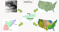
Land surface hydrography now supports the modelling of continental-scale streamflow at high resolution and in near real time. The US National Hydrography Dataset contains about 2.7 million stream segments averaging...
This site uses cookies. By continuing to use this website, you agree to our Cookies Policy. Agree