IENCs in Flanders
Safety of navigation on inland waterways is as important as in maritime waters. To guarantee this, Electronic Navigational Charts (ENCs) have now been produced for several years. As inland waterways...
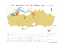
Safety of navigation on inland waterways is as important as in maritime waters. To guarantee this, Electronic Navigational Charts (ENCs) have now been produced for several years. As inland waterways...
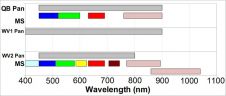
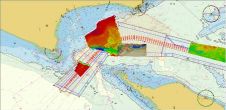
Proteus FZC, EOMAP and DigitalGlobe have formed a partnership to bring satellite-derived bathymetry and seabed classification to the hydrographic community. A pilot conducted by UKHO in the Mediterranean confirms that...
Having demonstrated its Virtual Library to great acclaim at SMM in Hamburg in September 2012, the Institute of Marine Engineering, Science and Technology (IMarEST, UK) has made the service available...
CARIS has recently completed a successful project for the provision of a bathymetrical database system for the Port of Melbourne Corporation (PoMC, Australia). PoMC conducts regular bathymetric surveys as part...
Esri, USA, has released a solution to support users in port management, maritime transport, coastal management, offshore energy, nautical chart production, and maritime defence. ArcGIS for Maritime: Charting and ArcGIS...
SeaZone’s HydroSpatial 2 Base is available ‘off the shelf’ for 40% of the world ocean. HydroSpatial 2 Base is the foundation layer in the HydroSpatial 2 family. It is a...
Despite the best efforts of Hydrographic Offices (HOs) around the world, the ENCs that are on the market today do not always depict the real world as accurately as would...

Soundings and contours are the only official way data producers can push bathymetric information to the wide hydrographic community. The introduction of the S-102 standard for bathymetry will enable many...

With effect from 1 April 2011, a coastal monitoring programme is in place for the entire English coastline via a national network of coastal monitoring programmes. In addition to the...
Open Geospatial Consortium has adopted the PUCK standard, which facilitates plug-and-play connections of electronic equipment. The standard is relatively simple, and several manufacturers have already implemented the protocol in their...
This site uses cookies. By continuing to use this website, you agree to our Cookies Policy. Agree