Aaron Lim
Aaron Lim is a lecturer in Coastal Geomorphology and director of the MSc in Coastal and Marine Management at University College Cork. Aaron’s research interests include applied seafloor mapping, seabed...

Aaron Lim is a lecturer in Coastal Geomorphology and director of the MSc in Coastal and Marine Management at University College Cork. Aaron’s research interests include applied seafloor mapping, seabed...
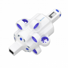
Hydrus is a micro-autonomous underwater vehicle that makes marine surveying easy and affordable. Hydrus takes the drone revolution underwater with the most advanced navigation and communication systems of any subsea...
The esteemed Finnish Geospatial Research Institute (FGI) is set to utilize advanced Lidar systems developed by the Fraunhofer Institute for Physical Measurement Techniques IPM for future maritime surface surveys. Anticipating...
Aspect Land & Hydrographic Surveys Ltd is one of the leading independent coastal survey companies in the UK, with extensive experience and a proven track record in providing high-resolution hydrographic,...
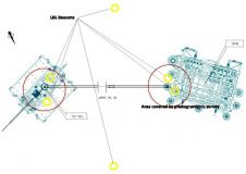
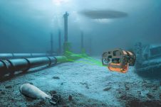
Subsea metrology is one of the most challenging tasks for surveyors engaged in marine construction. Metrology involves determining the distance and relative attitudes of objects on or close to the...
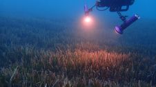
The ocean plays a crucial role in mitigating climate change, yet we lack detailed information on over 95% of the seafloor. This article explores planblue’s solution to accelerate time-to-data and...

Ephraim Friedli is an engineering specialist at Axpo Power AG, where he is responsible for bathymetric measurements in the Hydro & Biomass division. He previously worked as a scientific assistant...
Terradepth is an ocean data-as-a-service company focused on scaling ocean data collection and dissemination, enabling unprecedented exploration of the underwater environment. Their unique end-to-end solutions increase maritime operational efficiency with...
Topodrone, a Swiss-based designer and manufacturer of high-precision Lidar equipment for installation on drones, vehicles and backpacks, has launched Aquamapper, a UAV-based solution for bathymetric surveying and marine construction. The...
This site uses cookies. By continuing to use this website, you agree to our Cookies Policy. Agree