From seabed to cloud: ground-truthing seagrass data
Adding credibility and scalability to the blue carbon market
The ocean plays a crucial role in mitigating climate change, yet we lack detailed information on over 95% of the seafloor. This article explores planblue’s solution to accelerate time-to-data and the accuracy of seabed mapping, showcased by several successful case studies. Planblue’s technology combines underwater hyperspectral imaging, RGB imaging and underwater navigation with an AI-driven automated data processing pipeline. Overcoming challenges relating to geolocation, water column distortion and motion distortion, planblue’s data products add credibility to the blue carbon market.
70% of the Earth’s surface is covered by the ocean, which regulates the climate, absorbs carbon dioxide, provides food and supports biodiversity. The seafloor, as far as we know, is the best carbon sequester available, and can fix CO₂ up to 30 times faster than trees on land. Notably, seagrass exhibits remarkable CO₂ capture efficiency. Despite their pivotal role in mitigating climate change, seagrass meadows face inadequate recognition and protection due to limited data on their distribution. They are heavily underrepresented in policy-making and finance decisions around climate mitigation. In fact, of all the United Nations Sustainable Development Goals, Goal 14 ‘Life below water’ has received the least amount of public money. To tap into the large carbon sequestration potential of the ocean, we need to finance projects for seafloor restoration and preservation. Access to credible data is essential to accelerate the blue carbon market, including blue carbon credits and Nationally Determined Contributions (NDCs) to meet the Paris Agreement.
Mapping the seafloor and measuring carbon
Planblue was founded in 2017 by two former marine scientists and two engineers to enable high-quality seafloor mapping, inspired by satellite technology. Based in Bremen, Germany, the company now has over 25 employees. Using a novel seafloor mapping solution, planblue processes seafloor data from around the globe with the explicit goal to highlight the ecologic and economic value of the seafloor.
Replacing traditional seafloor mapping methods with highly automated and scalable processing pipelines, planblue can produce georeferenced seafloor maps at pace. Its goal is to add in-depth information to bathymetric maps, including the health state of the seafloor, carbon sequestration potential, biomass and biodiversity. The technology is capable of surveying anything on the seabed and mapping a variety of carbon sequestering ecosystems, including corals and seaweeds. For its first application, planblue has focused on seagrass meadows.
Speed and scale
As the world is running out of time to turn the tide on climate change and protect biodiversity, an important part of planblue’s mission is to provide speed and scale for the protection of vital ecosystems, replacing manual processes with automated pipelines based on state-of-the-art computing and AI. Traditional methods of ground-truthing aerial and satellite data require a time-intensive process of in situ collection of core samples from the seafloor and subsequent lab analysis. Planblue’s technology largely replaces this with near in situ remote sensing, using hyperspectral cameras and a selection of sensors to correct distortions of the images in the water column. As planblue controls the entire data chain, it can ensure a seamless and speedy process, even in areas with limited internet access during field campaigns. By implementing these streamlined processes, planblue can reduce time-to-data from weeks or sometimes months to days or even hours.

Measuring Mediterranean seagrass
Normalization of data is essential to meaningfully compare results over time, between locations or with other remote sensing technologies. Since planblue started six years ago, its technology has been tested and improved through several campaigns around the world. This article zooms in on two crucial surveys in the Mediterranean, in France and Turkey. In October 2022, planblue first tested a selection of new sensors in Nice, France, that were added to increase the accuracy of the AI and other algorithms. The survey in May 2023, east of Bodrum in Turkey, gave a unique opportunity to compare the outcomes of the algorithms with the manual measurements collected at the location over the past years and with the data from the Nice campaign.
A new dimension to seafloor mapping
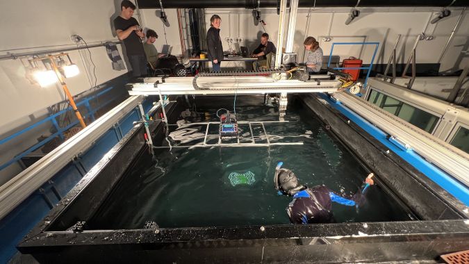
With the ambition to create a comprehensive representation of underwater areas and their changes over time, the first step for planblue is the creation of orthoimagery of the seafloor. Through its automated pipelines, planblue’s technology can stitch thousands of images together in less than 24 hours after the seafloor data has been collected. Underwater navigation and geolocation are however essential for accurate mapping and meaningful data processing. While AUVs have this technology built in, planblue developed its own in-house navigation system for the diver-operated DiveRay. This technology ensures precise positioning of the imagery on the seabed, making accurate mapping and year-on-year comparison possible.
Working with hyperspectral data presented an additional challenge. The hyperspectral camera is a push-broom scanner, which means that movement of the camera through the water introduces distortions in the captured images. Using data from the navigation and other sensors, planblue was able to adjust for the motion in the data processing. By combining this with the georeferenced data, planblue can create an overlay of hyperspectral data on top of an RGB image and produce advanced maps of the seafloor. There are however a few more obstacles to overcome to deliver high-quality, accurate and meaningful information.
Making turbid water crystal clear
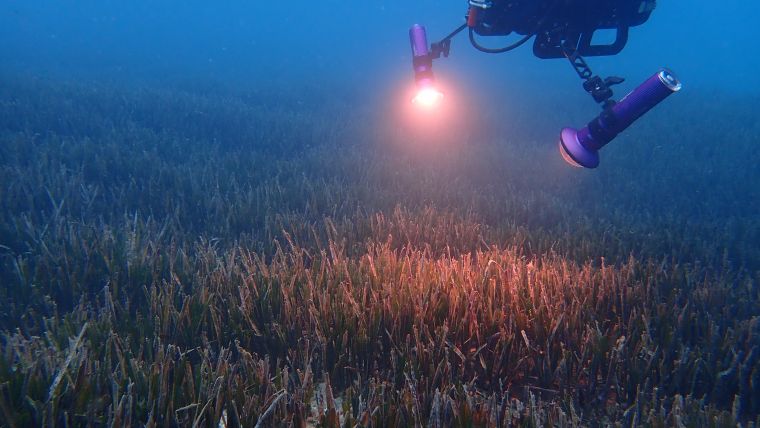
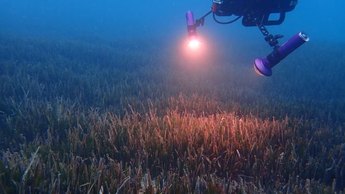
As with any form of remote sensing, one of the challenges that planblue needs to address is the correction of distortion of the observations. Planblue’s DiveRay typically operates about two metres above the seafloor. To accurately assess the properties of the vegetation or sediment, the observations need to be compensated for the water column between the DiveRay and the seabed.
While the space community has worked on compensation for light travelling through the atmosphere for many decades, this kind of work is still in very early stages underwater. The survey in Nice in 2022 was the first opportunity for planblue to test new sensors that gather data required to adjust for varying conditions such as depth, weather, turbidity and other environmental properties. One of the sensors that was introduced measures downwelling irradiance, which makes it possible to determine how the light is diffused by depth, turbidity and other disruptions in the water column.
After Nice, the follow-up campaign in Turkey presented an opportunity to test the effectiveness of the data processing further by comparing measurements from the two campaigns. Both surveys took place in the Mediterranean Sea with similar ecosystems, observing the same species of seagrass, Posidonia oceanica. However, the environmental conditions differed. In Nice, the conditions were consistent, slightly sunny weather and observations at a depth of 5–6 metres. In Turkey, the water was deeper, at 25–30 metres, as the project measured the edge of the seagrass. The weather conditions were also variable, with some sunny days but also rain. The findings of these two campaigns provided valuable input to enhance the data processing pipelines.
Size matters
Another challenge with underwater imaging is scaling. Objects underwater seem closer than they really are, and how much closer depends on the water conditions. For this reason, scaling is a fundamental challenge to anyone working with underwater photogrammetry. Usually, a correction is carried out manually with a variety of visual aids, such as markers and scale bars, and incorporated into the post processing workflow to estimate the scaling introduced by the water. As planblue’s mission is to automate as much as possible, it developed its own proprietary field of view correction model to manage this. Combining the geolocation from the navigation solution and distance of the camera to the seafloor, planblue’s technology can calculate the scaling factor of the water.
Big picture
Planblue has therefore made some extensive adjustments to its data processing flow to derive georeferenced benthic reflectance. In the case of hyperspectral images, it is essential to apply corrections to the data. Instead of creating visual images, the observations from the hyperspectral camera generate numbers that are used to compute indices, which would be meaningless if not calibrated and validated. The purpose is to obtain objective measurements that are independent of the conditions encountered in the field or caused by the device. All the metadata measured in the field is time stamped and carefully logged to feed the intermediate processing pipelines that will generate the maps and overlays.
Although a lot of this is now integrated into the automated workflow, full automation of the data analysis remains a work in progress – fine tuning and optimizing the process. As more of these technical challenges are solved in the data processing pipelines, it speeds up how quickly final data products can be delivered to customers. This reduction in time-to-data conversion can support more data-driven decision-making for sustainable marine management. To scale up the reach of the data products, planblue is expanding its operational capacity by integrating its technology as a sensor package into existing underwater drones.
Adding credibility to the blue carbon market
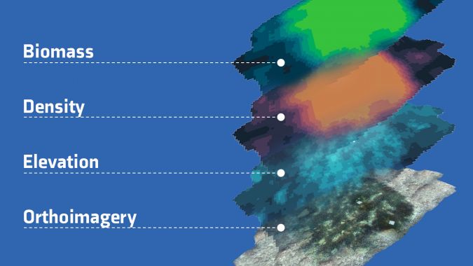
The comprehensive datasets collected using planblue’s technology can be used to visualize seasonal changes in marine ecosystems. The hyperspectral overlays on the orthoimagery of the seafloor get to the essence of what planblue’s technology has to offer. The data collected with the hyperspectral and RGB cameras provides detailed insights, for example into the health, biomass and density of seagrass. This information can revolutionize marine conservation, preservation and restoration. Knowing not just whether seagrass is present, but also the state it is in, can ensure that policymakers focus on the areas where most impact can be made. After all, unhealthy seagrass meadows can become net emitters of CO₂, while healthy seagrass sequesters carbon up to 30 times faster than a rainforest. This thorough assessment of seagrass meadows can take blue carbon projects to the next level and provide the credibility needed to attract investors and accelerate the market.
Conclusion
Planblue’s underwater geospatial technology is driving a transformation in the blue carbon industry, speeding up the protection of vital marine ecosystems with almost instant, credible and accurate data. The seafloor plays a critical role in regulating the climate, absorbing carbon dioxide and supporting biodiversity. However, it remains an undervalued and underfinanced carbon sink, lacking detailed information to drive meaningful conservation efforts.
In the recent surveys in France and Turkey, planblue tested and improved its innovative seafloor mapping solution. Equipped with hyperspectral and RGB imaging capabilities, the company has successfully created objective ground truth data by overcoming challenges with water column distortions and georeferencing. The comprehensive datasets generated during these campaigns offer detailed insight into seagrass health, biomass, density and carbon sequestration potential. With reliable data, investors and policymakers can focus their efforts where they can make the most significant impact, both economically and ecologically.

Value staying current with hydrography?
Stay on the map with our expertly curated newsletters.
We provide educational insights, industry updates, and inspiring stories from the world of hydrography to help you learn, grow, and navigate your field with confidence. Don't miss out - subscribe today and ensure you're always informed, educated, and inspired by the latest in hydrographic technology and research.
Choose your newsletter(s)


