Hydrography 2.0
This month's theme is hydrography and living resources. However, you won't find any articles on the subject in this magazine. A bit strange coming from me, who for years worked...
This month's theme is hydrography and living resources. However, you won't find any articles on the subject in this magazine. A bit strange coming from me, who for years worked...
Accurate real-time measurement of waves, winds and currents at long range, across a large area providing critical data to organisations who need to monitor and gain understanding of environmental processes....
In soil and sediment studies, geophysical mapping is often used as a prerequisite to focus or guide traditional sampling and coring of the locations of interest. This way, synoptic and...
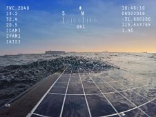
Australian company Fastwave has released the Go Remote photo and video imaging system for acquiring and delivering imagery in real time, from anywhere in the world, directly to end-user visualisation,...
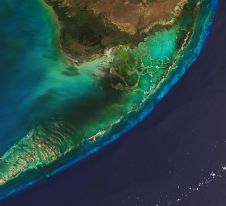
The Florida Department of Environmental Protection has commissioned Woolpert to acquire bathymetric survey data using Lidar technologies to support the Florida Seafloor Mapping Initiative (FSMI) and its mission to produce...
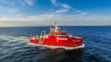
Fugro has finalized an agreement to acquire two platform supply vessels, namely Sea Goldcrest and Sea Gull, to be utilized as geotechnical assets. This strategic move reflects the company’s anticipation...
This site uses cookies. By continuing to use this website, you agree to our Cookies Policy. Agree