Accelerating subsea data processing using artificial intelligence
From broad brush filtering to pinpoint intelligent data selection
Artificial intelligence (AI) first came to light in the 1950s, when the ability of a machine to undertake an operation and adapt to changing conditions without human input was skirting the edges of science fiction. The mainstream recognition the topic now enjoys is due partly to having enough computing power to make AI work for us. Artificially smart machines and software are no longer science fiction, and the consequences are everywhere, including in geophysical data processing.
Developments in the hydroacoustic technology sector have made the final mile in the subsea survey value chain closer to a 100-metre sprint. Post-processing is much faster these days, because geophysical data acquired by multibeam echosounders, bathymetric sonars and sub-bottom profilers is cleaner than it ever was. Improvements to transducers, motion sensors and positioning technology combine with improved onboard processing to significantly reduce the time it takes for clients to see the final data.
Optimizing offshore wind
Survey costs are always under scrutiny, but massive growth in the offshore wind sector will add more pressure to optimize the entire value chain for speed and efficiency. New wind capacity is coming online regularly, with January’s announcement that Germany has approved new wind farms to the measure of 1.9GW just the latest in a long line of new projects.
Offshore wind power must remain competitively priced to realize its potential as a fossil fuel replacement however, and energy companies, their prime contractors and operational partners will continue to seek out the most competitive offering as long as the provider can deliver the standard of data required.
AI and its machine learning counterpart have the potential to further accelerate the entire journey of data from the seabed or below it to the desks of the engineers that depend on it. Reducing the time from commission to delivery can make marine survey services more affordable, thereby providing companies that invest in innovative solutions with a more competitive edge in their respective markets.
AI and geophysical data
In this context, the application of AI and machine learning to geophysical data will not always be a choice, as survey companies with offshore wind clients must demonstrate a noticeably clear value proposition to remain competitive. Fortunately, new AI technologies are coming through the development pipeline to streamline data handling and processing, leading to tangible cost reduction opportunities. One such technology is being worked on in a partnership between the University of East Anglia and underwater instruments manufacturer GeoAcoustics.
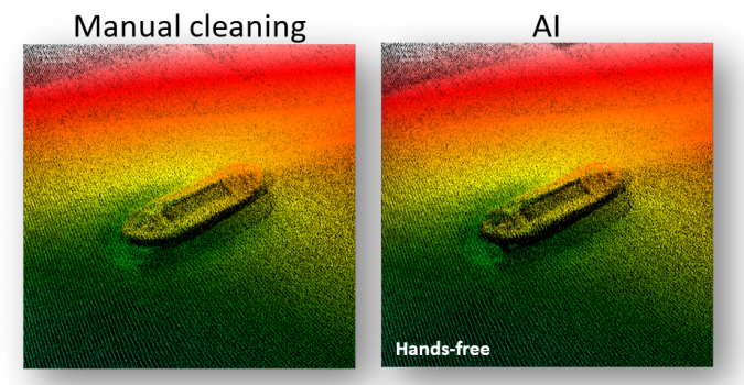
The team is focused on the creation of an AI-powered upgrade to existing automated filtering in the GeoSwath 4 bathymetric sonar software. The project stands out as its aim is to apply machine learning so that the AI can remove surplus and undesired data autonomously; during acquisition, the system is designed to log virtually clean data, without any user intervention in the cleaning process. This is made possible as the AI was developed to analyse and accept or reject outlying soundings. The user only needs to pay attention to data quality and coverage, and during post-survey processing the focus can be purely on georeferencing of the bathymetric data using deterministic calculations. The final, noise-free and high-resolution bathy products will be fully reproducible with minimal human intervention, with the potential for savings achieved to be passed on to the client.
Accelerating interferometry
For GeoAcoustics, the project is a means for the lower-cost GeoSwath bathymetric sonar system to go head-to-head with more expensive multibeam echosounders. GeoSwath provides ultra-high-resolution swath bathymetry with up to 12 times water depth seabed coverage and a 240° field of view. On these figures alone, the system outperforms even the most expensive shallow water multibeam systems.
The performance is due to the use of interferometry, a methodology that acquires significantly more data than a multibeam echosounder could along the same survey line. It also works as a side-scan sonar, for example enabling highly detailed images of the base of wind turbine monopiles and cables on the seabed alongside the acquired bathymetric data.
Currently, a set of manually configured filters is employed to process GeoSwath data. To achieve the best results, an experienced user is required to optimize these parameter settings – particularly when operated in real time and in varying environmental conditions. The AI instead provides automated real-time filtering at the click of a single button, without the need for further human intervention, providing clean user-independent data.
The AI processing ensures that sonar-dependent IHO-conformant data can be viewed in real time during acquisition, allowing for dynamic line planning to ensure the collected data meets the required IHO spec for the survey. Traditionally, this is performed onshore after data collection and further surveys would be commissioned if the original data was found to not meet the required spec. AI processing during the initial survey can mitigate this risk and in doing so save time and reduce fuel consumption. The latter of course has the extra advantage of boosting the green credentials of the survey provider.
AI in action
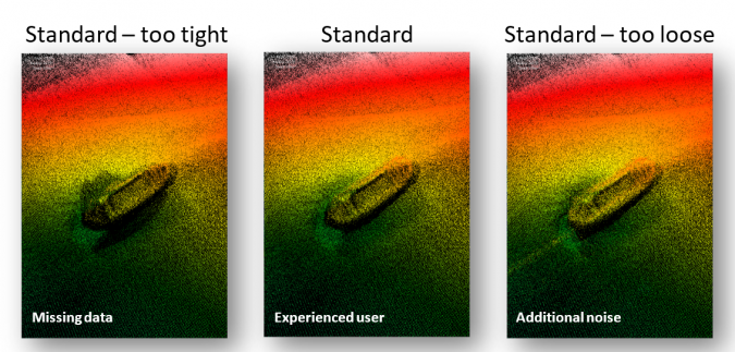
AI techniques can be used for both real-time data processing and post-processing of bathymetric data. The traditional approach to filter data from a GeoSwath system is to set a number of filters to remove unwanted points. These consist of an amplitude filter, a limits filter, an across track filter and an along track filter. If the area being surveyed is relatively consistent then these settings can be applied and the survey undertaken, however in challenging environments these settings may need to be optimized in real time, which requires operator experience.
By setting the filters too tight (narrow band) around the seabed, any outliers in the water column are removed but there is the potential of chopping off the top of vertical structures on the seabed. If the filters are set too loose, vertical structures are retained but the data is compromised by adding more outliers from the water column. The middle image shows the optimum balance of filters to capture the entire wreck structure while eliminating as many water column outliers as possible; this was achieved by an experienced operator.
The aim of the AI work is to reduce the need for experienced operators and the subjective decisions that they will make. No two operators will generate identical data products based upon the decisions that they apply.
Augmented efficiency
Through this data, we can see that the AI processing toolset provides comparable results to what an expert operator could achieve in the same time frame. Of course, the ability of an AI system to perform so well might be construed as a threat to those professionals whose knowledge, skills and experience are the lifeblood of the marine survey industry.
However, AI data processing will not replace marine surveyors; instead, it will help them to do their job even more efficiently, which in the context of changing demands driven by offshore wind energy, will help to secure jobs and benefit the hydrographic survey market as a whole.

Value staying current with hydrography?
Stay on the map with our expertly curated newsletters.
We provide educational insights, industry updates, and inspiring stories from the world of hydrography to help you learn, grow, and navigate your field with confidence. Don't miss out - subscribe today and ensure you're always informed, educated, and inspired by the latest in hydrographic technology and research.
Choose your newsletter(s)


