Addressing change in coastal environments with advanced topobathymetric elevation modelling
The hydrospatial data collection approach in Morro Bay
Morro Bay, a shallow coastal estuary located near San Luis Obispo, California, supports an abundance of wildlife and is home to a vibrant outdoor community. However, changes – such as sedimentation and a substantial loss of eelgrass – have had an impact on the landscape. To better understand how the environment is changing and to gain insight into mitigation strategies, key stakeholders – including the Morro Bay National Estuary Program (NEP), the National Oceanic and Atmospheric Administration (NOAA) Office for Coastal Management (OCM) and NV5 Geospatial – have joined forces to create a comprehensive topobathymetric elevation model of the bay and coastline.
The Morro Bay coastal estuary is a natural treasure. The 2,300-acre (9.3km2) estuary features salt marshes and mudflats and is home to more than 250 species of land, sea and shore birds and dozens of endangered species, including peregrine falcons. The estuary and the bay also attract an abundance of other wildlife – from sea otters to shellfish – as well as the aquatic vegetation that provides habitat for these species while helping to maintain the bay’s water quality. Morro Bay is also home to a vibrant coastal community, where residents and visitors kayak, fish, hike, birdwatch and enjoy nature on its unspoiled beaches.
However, like many areas, Morro Bay is experiencing significant environmental change. Historical sedimentation and loss of vital eelgrass, combined with other factors, are impacting the landscape and creating a perfect storm that could forever alter the estuary’s unique ecosystem. To better understand how the environment is changing and to gain insights into mitigation strategies, the Morro Bay NEP, NOAA OCM and NV5 Geospatial and its partners have joined forces. The first step is to create a comprehensive map of the bay area terrain, both above and below the water, with the goal to develop a topographic and bathymetric elevation model using state-of-the-art technology.
High volume of sediment change
Comprising approximately 2,300 acres (9.3km2) of shallow, semi-enclosed intertidal and subtidal habitat, the Morro Bay estuary is bordered to the west by a four-mile vegetated natural sandspit that separates Morro Bay from the Pacific Ocean. The Morro Bay watershed includes freshwater inflows delivered to the estuary via the Chorro Creek and Los Osos Creek sub-watersheds and through groundwater seepage in the Los Osos area. While areas around Chorro Creek are used in a variety of ways – from rangeland, a national forest and an ecological reserve to a National Guard Army base, the Los Osos sub-watershed also includes row crop agriculture and commercial greenhouse nurseries. Human activities in both could be impacting water quality within the Morro Bay watershed and estuary.
One of the biggest challenges faced in this area is the high volume of sediment change in the bay, which has been hastened by the loss of native eelgrass, which helps to stabilize sediments and maintain healthy oxygen levels in the water. The group wanted to examine the factors contributing to changes in the sediment movement or geomorphology. The result was a project using state-of-the-art aerial topobathymetric Lidar technology combined with vessel-based interferometric sidescan sonar and water level monitoring stations to characterize Morro Bay. The data could then help support coastal resource managers, watershed managers and other stakeholders in decision-making processes, including hydrodynamic modelling.

Combining Lidar and sonar
To start, the partners needed to understand tidal patterns and water clarity to determine the best time for data acquisition. After observing six-foot tide swings, they opted for low-tide data acquisition via an airplane equipped with a RIEGL 880-G2 Lidar sensor system for mapping shallow water bathymetry. The system, with a green wavelength laser that penetrates the water column, enabled them to map areas with water at depths of as much as 2.5 metres along the coasts and in marshy areas.
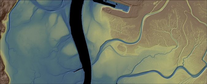
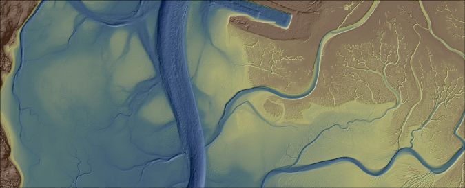
While the Lidar survey covered much of the coastline and shallow areas, there was still an area in the middle of the bay that was too deep for laser detection and was therefore left unmapped. To complete the picture, interferometric sidescan sonar technology was used over an area of more than 352 acres (1.4km2).
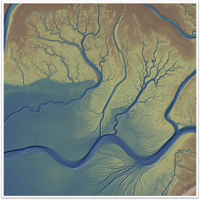
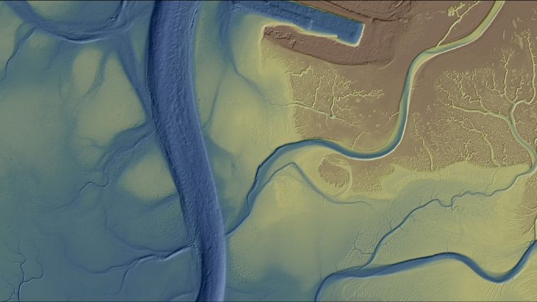
Despite challenges posed by naturally moving sand, maintenance dredging activities and areas of thick healthy eelgrass that were hard to penetrate with Lidar and sonar, the project showcased the strength of these complementary technologies. The combination of Lidar and sonar enabled the partners to create a high-resolution seamless elevation model for the whole bay, depicting both land and sea.
The resulting integrated elevation model of Morro Bay offers a detailed look at the geography. The data collected exceeds the vertical accuracy of Quality Level 2b (~30cm) specified in the NOAA National Coastal Mapping Strategy 1.0, Coastal Lidar Elevation for a 3D Nation. The topographic Lidar achieved less than 5cm vertical accuracy at the 95% confidence level and bathymetric Lidar achieved 10cm accuracy (95% confidence level) against shallow water survey checkpoints. Additionally, the bathymetric Lidar was able to cover the nearshore gaps that are traditionally left unmapped by sonar systems (due to shallow depths), as well as other shallow areas typical of estuarine environments and embayments.
Unearthing valuable insights for revitalization efforts
The data collected across Morro Bay offers valuable scientific insights into geomorphic changes in the area. With the 2019 topobathymetric elevation model serving as a baseline, a variety of stakeholders have been able to leverage the survey data to help understand sediment transport, aid restoration efforts, make changes to improve water quality and generally support improvements in coastal resilience.
Perhaps one of the most prominent research projects to leverage the survey data is that concerning the study and reintroduction of the eelgrass habitat in Morro Bay. Loss of seagrass is a significant issue worldwide, with climate change adversely impacting its habitats. Morro Bay has had a long history of healthy eelgrass growth, but 2007 marked the start of a massive decline, with eelgrass beds decreasing from 350 acres (1.4km2) to just 15 acres (0.06km2) in only five years – more than a 95% decline.
This dramatic change is a major concern since eelgrass serves many functions in the environment, including being a direct food source for the migratory black brant goose. Through photosynthesis, eelgrass provides oxygen in the water, and its roots hold the bay sediment in place, improving water clarity and preventing erosion. The plant’s floating structures also dampen wave action, keeping the water clearer to let light in, and serve as a canopy beneath which wildlife can remain safe from predators.
Researchers at California Polytechnic State University-San Luis Obispo and their partners identified a relationship between the bay’s eelgrass collapse and widespread erosion. Their study showed that places that lost eelgrass during the major decline experienced substantial erosion, while places that maintained eelgrass did not. This followed up on an earlier study that showed that the water quality conditions where eelgrass died out – mostly in the southern and back part of the bay – were defined by higher temperatures and salinity, lower oxygen levels and higher turbidity, limiting light penetration. These areas also experienced limited flushing, with water being trapped for longer than in areas where eelgrass remained healthy. However, at the mouth of the bay where there was strong oceanic tidal influence, waters were cooler, clearer and more oxygenated, which are conditions conducive to eelgrass health.

Leveraging findings from the Cal Poly study and the combination of Lidar and sonar data collected during elevation modelling, the Morro Bay NEP has been able to pinpoint sites that offer optimal depths and other conditions for eelgrass restoration efforts. Additionally, data collected by ongoing water quality monitoring stations in the bay (such as the work conducted by the Central and Northern California Ocean Observing System) provides continued information about factors such as the bay’s hydrodynamics, sedimentation and water quality, which influence resilience and habitat conditions.
These studies of the topobathymetric data and water levels have helped researchers to successfully restore eelgrass beds, inform bay area adaptation strategies, and serve as a prototype that could influence global seagrass conservation strategies. However, the geographic data and elevation modelling may ultimately have an even greater impact. The data collection approach in Morro Bay could serve as a model for others to better understand factors that impact coastal resilience and provide the insights necessary to foster a healthy natural ecosystem and ensure that our coastlines, estuaries and bays remain national treasures.


Value staying current with hydrography?
Stay on the map with our expertly curated newsletters.
We provide educational insights, industry updates, and inspiring stories from the world of hydrography to help you learn, grow, and navigate your field with confidence. Don't miss out - subscribe today and ensure you're always informed, educated, and inspired by the latest in hydrographic technology and research.
Choose your newsletter(s)


