From Papyrus to Electronic Charts
Modernising Fluvial Charts in the Amazon Region of Peru
The Amazon is the world’s largest river system. With more than 50,000km of navigable waters, ocean-going vessels are able to transit almost 6,000km from its mouth in the Atlantic Ocean to Iquitos, Peru. The Amazon and its more than 1,000 tributary rivers are characterised by rapid changes in water levels and current flow causing constant erosion and sedimentation. The need to continually monitor the location of river banks and channels presents an enormous challenge to those responsible for providing necessary hydrographic services to ensure safe fluvial navigation throughout the vast region.
The Amazon River basin is approximately 7,050,000km2 in total area, occupying almost 40% of the South American continent. The Amazon is the widest and longest navigable river in the world.
With an average discharge greater than the next seven largest rivers combined, it accounts for approximately one-fifth of the world's total river flow. The Amazon and its more than 1,000 tributary rivers are characterised by rapid changes in water levels and current flow. These rivers constantly erode and deposit sediment, requiring continuous monitoring of the location of river banks and channels.
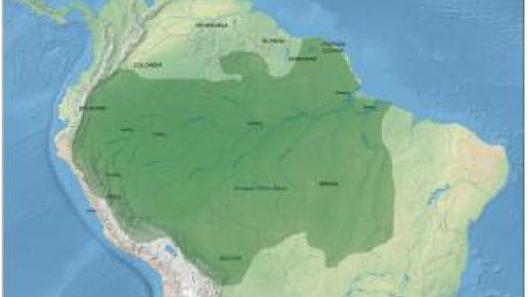
Amazon River System in Peru
The Amazon region of Peru is approximately 760,000km2 and comprises about 62% of the country. All rivers in the Amazon region are geologically young, constantly changing course, eroding their banks, and forming new land masses. This process of erosion and sedimentation is largely due to the great temporal variation in water levels that is characteristic of the entire region. Changes in water level are typically 9-10m from the dry to rainy season. Because of the remote location and density of the jungle, there are few roads or railways. For the indigenous population, fluvial networks serve as natural highways -- the primary means of communication and transportation for thousands of individuals and huge quantities of products.
There are over 14,000km of navigable rivers in Peru. However, the network formed by the Amazon, Marañón, Ucayali, and Huallaga rivers is of great importance for commercial transport. Iquitos, Pucallpa and Yurimaguas are the main trade centers serving as hubs to supply nearby towns in the Peruvian Amazon.
The Amazon River is navigable from the Atlantic Ocean to Iquitos for vessels up to 4.5m of draft and 100 to 200 tons capacity. However, for all rivers in the Peruvian Amazon, passengers and cargo are transported in a wide variety vessels ranging from tug/barge convoys, ferries, small outboard motor boats (called a ‘pequepeque'), and dugout canoes.
Brief History of SEHINAV
In 2011, El Servicio de Hidrografia y Navegación de la Amazonia (The Service of Hydrography and Navigation of the Amazon [SEHINAV]) celebrates its 40th anniversary. As such, it is useful to take a retrospective look at past accomplishments, as well as Peru's plan to address future challenges in providing hydrographic services for the world´s most dynamic river system.
Hydrographic activities in the Amazon Region first began in 1864 with the creation of Naval Station Riverside Loreto. Later, the Comision Hidrografia Exploradora de la Montaña, was established in Iquitos in 1867 under the command of Admiral John Tucker, who overcame many navigational and logistical obstacles to complete the first hydrographic survey of the region. This pioneering work, over four years, was the genesis of the national Directorate of Hydrography and Navigation (DHN), of the Peruvian Navy, which was established in 1903.
El Servicio de Hidrografia y Navegación de la Amazonia (SEHINAV) was officially created on 18 August 1971 as a decentralised technical body of the DHN. Since then, SEHINAV has become increasingly active in the fields of hydrography, cartography, navigation, and signalling. It also conducts co-operative research projects with public and private institutions.
In 1981, the SEHINAV office moved to Punchana, near Iquitos. Initially, there were no trained hydrographers. Instead, the office was staffed by navigators with practical knowledge, but no geographical frame of reference. As such, Peruvian Navy personnel were sent to Lima to receive training at DHN headquarters in Callao. The first class of formally trained hydrographers arrived in Iquitos in 1983.
Traditional Papyrus charts
Prior to 1983, fluvial (i.e. river) charts were produced entirely by hand. Drawn in pencil on papyrus, each chart was based on visual observations of crew aboard survey launches, coupled with narratives provided by local navigators. Sections of papyrus were then pieced together like a puzzle to provide a continuous chart of a sector, which was in turn placed on rollers to be viewed using a light box.
All physical features were indicated by a rudimentary scheme without geographic reference. No soundings were taken, and distances were expressed solely in terms of sailing times or number of curves to be encountered in the river. These charts were updated as new information became available. The first ‘official' charts were actually traced versions of these charts that were reproduced and then distributed.
Initially, only the areas near the cities of Pucallpa and Iquitos were surveyed and charted. Limitations endemic to a vast and sparsely populated region hampered efforts to expand the scope of the surveys. Survey crews had no appropriate positioning system, in light of difficulties with dead reckoning while navigating sinuous rivers. And attempts to utilise land-based celestial observers were met with logistical problems (lodging, alimentation, etc.). Moreover, launch crew suffered from logistical issues of their own (refueling, taking on stores, etc). Communications were severely constrained. Over time, most of these issues have been resolved through technological development.
However, since SEHINAV surveys a vast region that is changing all the time, it focuses not just on the survey, but the dynamics. And developing good statistical data remains a challenge. SEHINAV maintains a database with levels for all the rivers based on information provided by staff gages based throughout. The Iquitos office has been located in the same place for 40 years, so reliable information is available with respect to morphology and predictable patterns at that site. However, this is not the case for all the rivers in the region and the mean is changing all the time. So special care must be taken in reporting what the readings are based on. Communications with remote sites remains an issue.
Geo-referenced Papyrus Charts
A long-range hydrographic survey vessel, B.A.P. Stiglich, was assigned to SEHINAV in Iquitos when the first formally trained hydrographers arrived in 1983. These events greatly increased the ability to move between cities and conduct geo-referenced hydrographic surveys. With the advent of radar capability, during 1983-1996 shoreline profiles were hand-traced on bleached X-ray film that was placed over the vessel's radar console.
The X-ray film profiles were then pieced together like a puzzle and placed over a geographic coordinate system, which was in turn traced on papyrus to produce more sophisticated, multi-level charts.
Versions of papyrus charts were sold until 1998. This format remains popular with some local mariners who purchase modern charts, then trace them back onto traditional papyrus for their ease of use.
Electronic Nautical Charts
Beginning in 1997, when GIS software became available, satellite imagery became an important means to define the location of river banks. Currently, Fluvial Chart Books of the main river systems in Peru are published by SEHINAV every 6-12 months. The key information shown on each chart is the present location/configuration of the riverbank, and the location/depth of the main river channel.
Special procedures and equipment are required to conduct surveys and produce charts of the dynamic Amazon. It is beyond the scope of this contribution to discuss the used procedures and equipment.
Looking to the Future
Most commercial vessels operating in the Amazon region of Peru lack sophisticated navigation systems. This is changing with the increasing use of radar and GPS for positioning. As such, SEHINAV is taking steps towards modernising fluvial charts and is looking into providing them in electronic format. Initially, raster may be preferred over vector format since they can be easily produced by scanning printed fluvial charts. Given the constantly changing river, raster charts are also more inexpensive to use. To date, raster charts have been completed for approximately 500km of the Amazon River from Iquitos to Santa Rosa, Peru, at the border with Colombia and Brazil.
Electronic charts are welcome and readily adopted by mariners carrying appropriate equipment. However, most mariners in the region have yet to experience the benefits of modern navigation, and are reluctant to invest in new equipment. This attitude is changing as some local vessel owners are experimenting with inexpensive GPS systems coupled with second hand computers.
Peru fully supports the development and use of international standards for maritime ENCs through its membership of the International Hydrographic Organization (IHO). For producing fluvial charts in vector chart format, DHN has recently become a member of the Inland ENC Harmonization Group (IEHG).
Current scenarios for expanding an intra-country, multi-modal transport route between the Atlantic and Pacific oceans have centered attention on the Amazon River system. SEHINAV is investigating land and waterborne routes with economic implications for both regional and international development.
While there are major challenges associated with providing hydrographic services for the Amazon River system in Peru, there is also an opportunity to use the right mix of hydrographic survey equipment to provide practical products and services that benefit both present and future users.
Acknowledgements
Many thanks to Dr. Lee Alexander (Univ. of New Hampshire) and Helena Rowland for their editorial assistance and advice.

Value staying current with hydrography?
Stay on the map with our expertly curated newsletters.
We provide educational insights, industry updates, and inspiring stories from the world of hydrography to help you learn, grow, and navigate your field with confidence. Don't miss out - subscribe today and ensure you're always informed, educated, and inspired by the latest in hydrographic technology and research.
Choose your newsletter(s)


