Monitoring Marine Pollution
Detecting Offenders by Satellite in the Eastern Black Sea
An increase in marine traffic has recently been registered in the Black Sea, which is often accompanied by illegal oily water dumps, leaks during loading/off-loading operations and a higher risk of accidents. One of the primary tasks of ScanEx Research and Development Center is the operational satellite-based monitoring for real-time detection of oil spills and their sources. Repeat offenders of waste dumping and sources of pollution have been confidently identified, encouraging others to adopt a more responsible attitude towards the marine environment.
View Larger Map
According to statistics, transportation is the main source of world ocean pollution. This is also the case for the Black Sea (Figure 1), where the transportation of oil products has an adverse impact on the marine environment and coastal zone, threatening the marine ecosystem. Oil pollution of water areas is generally caused by a number of different factors including dumps, bilge water waste, river run-off containing oil products, industrial and sewage waste, commercial facility emergencies and natural sources.
Pollution Monitoring
One of the primary tasks of ScanEx Research and Development Center (RDC) is the operational satellite-based monitoring for real-time detection of oil spills and their sources. An efficient solution to such a task is the system of monitoring based on Earth remote sensing tools and techniques. Satellite radar imaging is, in most cases, the only truly effective method of real-time monitoring of the seas around Russia, with a revisit period from several hours to several days. Radar imagery with high spatial resolution can be acquired to precisely determine the location and size of oil spills. Other advantages of radar images are their all-weather properties (although a wind speed of 3-8m/s is optimal for oil spill detection) and coverage of large areas of water. Oil-slick-like surface phenomena displayed on radar images can be created by quiet wind conditions, upwelling, rain cells, biogenic surface-active substances or phytoplankton flowering. During the processing of radar data, such phenomena are eliminated using additional information on wind, waves, sea surface temperatures and chlorophyll concentration.
Systems for monitoring oil spills by satellite are based on three core methods:
1. national radar space satellites, data reception, processing infrastructure and user terminals
2. purchase of radar data from foreign satellites, creation of proprietary reception and processing infrastructure, and own user terminals
3. purchase of user terminals to acquire products from foreign satellites via foreign infrastructure.
Kosmosnimki
The CleanSeaNet service is an example of the third listed method, implemented in 2007 by the European Maritime Safety Agency (EMSA) using Envisat-1 (European Space Agency) and Radarsat-1 (Canada) satellite imagery. The area covered by this service is, however, limited and does not include Russian waters. To solve this problem, the Russian ScanEx RDC has developed a technology to monitor oil spills, ships and ice by radar that is similar to the second listed method, referred to as Kosmosnimki (Seas of Russia, see website 1). This method is based on the near-real-time processing and analysis of radar data acquired by UniScan ground receiving stations in Moscow, Irkutsk and Magadan; license agreements permit direct reception from Envisat-1 and Radarsat-1 satellites.
ScanEx RDC has been fulfilling orders for operational imagery of Russian offshore areas for a diverse range of customers. Oil spill distribution maps or geoinformation integrated products are presented in a single information media and are delivered to the user within 1-2 hours after acquisition by the web-mapping service (website 1). The service enables real-time radar imagery to be displayed, with expert analysis of the current ecological situation in the water area. An integrated analysis of multi-temporal imagery, locating ships, imaging pollution and tracking its source is also available. Remote customers have access to such data without requiring specialist software or knowledge. Unlike the CleanSeaNet service, which only provides information about the presence of pollution and adjacent ships, Kosmosnimki also classifies pollution.
Port Collaboration
One of the most successful projects of ScanEx RDC is the regular satellite monitoring of the eastern waters of the Black Sea, carried out in collaboration with the Novorossiysk Seaport Administration. The pilot project was aimed at ensuring that a high regard for the environment was maintained in marine transportation, and was initially conducted within the area of Novorossiysk Port. One of the most important stages of the project was the creation of the internal automatic web-interface (geoportal) for operational supply of satellite data from the ScanEx reception and processing centre in Moscow to the Novorossiysk Seaport Authorities.
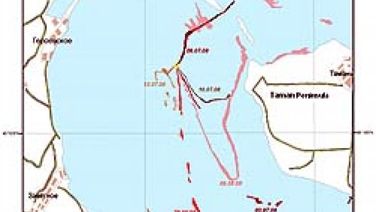
Volgoneft -139
An oil spill drift caused by the sunken front part of the Volgoneft-139 oil tanker was detected in the waters of the Kerch Strait. From 26 June to 6 August 2008, regular fuel oil seepage was registered in the form of thread-like tails. The pollution was distributed by surface winds, and streams sometimes acquired complicated and arched shapes. In a number of cases, slick drifting was registered towards the Taman Peninsular on the island of Tuzla. The pollution source was confidently identified using the geoinformation approach (Figure 2); the observed slicks could be perfectly correlated with the coordinates of the sunken tanker.
According to official representatives of the Russian Federal Agency for Marine and River Transport, these quickly processed images submitted to the authorities were used to make the decision to lift the sunken ship. The lifting and transportation operation of the fore-part of the tanker was completed on 14 August 2008. Thirty tons of fuel oil were pumped from the tanker, eliminating the source of pollution.
Detained Tanker
Imagery of the Novorossiysk Port area and approach also revealed interesting results. Radar imagery highlighted a number of spills from ships. A complex analysis carried out by the Novorossiysk Port Administration, backed up by surveys of ships using seaport services and correlation with ship navigation system data, was able to prove that illegal oil products were being dumped. One of the offenders was the Panamanian Rasim Akar tanker; vessel inspection revealed defects in the water-treatment equipment. The Rasim Akar probably became the first tanker to be detained following satellite radar monitoring in Russia. Four more tankers were later detained on charges of oil pollution, also as a result of satellite radar monitoring. Although the detection of polluters by satellite imagery has been in operation in many European countries for several years, it is only recently that this technology has been utilised in Russia.
Sea Monitoring
Satellite-based monitoring of oil pollution has supplemented the existing seaport control assets and expanded the area that can be surveyed. This enables water environmental monitoring to be extended to the entire eastern part of the Black Sea. On 42 of the 56 images acquired so far, human-induced pollution of different origin is observable (mostly due to spillages from ships; Figure 3). A considerable portion (15-17%) of marine pollution is waste from industrial facilities. Ship waste within the area of responsibility of Ukraine and Turkey has also been detected during the monitoring period. The maximum spill throughout the entire monitoring period (covering an area of 54,655km2) was registered within the area of responsibility of Turkey on 28 October 2008 (Figure 4). Changing Attitudes
According to data from the Novorossiysk Seaport Administration, the number of pollution incidents within the Russian sector of the Black Sea has decreased considerably during the monitoring period. This demonstrates that efforts to improve the situation by teaching environmental responsibility are working; the possibility of being monitored by satellite means that captains take a more responsible approach to issues of ecological safety. Regular satellite imagery allows ships to be located quickly and spills to be monitored in an emergency. Novorossiysk Seaport Administration authorities state that this method of monitoring the eastern waters of the Black Sea is very efficient. The joint project illustrates that space technology has increased the operational monitoring of shipping routes and environmental safety of seaports in Russia. ü
Acknowledgements
Novorossiysk Seaport Administration thanks ScanEx RDC for the development and supply of its service and looks forward to further collaboration.

Value staying current with hydrography?
Stay on the map with our expertly curated newsletters.
We provide educational insights, industry updates, and inspiring stories from the world of hydrography to help you learn, grow, and navigate your field with confidence. Don't miss out - subscribe today and ensure you're always informed, educated, and inspired by the latest in hydrographic technology and research.
Choose your newsletter(s)


