Operationalizing underwater hyperspectral imaging for blue carbon solutions
Providing a step change in ground-truthing hydrographic, aerial and satellite data
Much remains unknown about the benthic ecosystem that the blue economy depends on, and improved benthic habitat mapping is key to the sustainable development of the blue economy. While remote sensing technologies have achieved much, in situ (or near in situ) observation has lagged behind. With its underwater hyperspectral imaging (UHI) surveying platform and AI-driven automated data processing system, Bremen-based technology startup planblue is taking in situ observation to the next level.
After five years of system and product development, planblue GmbH is ready to offer its seafloor mapping products to the market. Planblue’s journey started in 2017, when it was founded as a spin-off of the Max Planck Institute for Marine Microbiology by four young scientists and engineers who shared a passion for diving. They understood that hyperspectral sensor technology combined with AI-driven data processing had the potential to replace the manual observation of benthic habitats by divers and subsequent subjective and time-consuming interpretation of the survey data with an objective and automated technology solution. Planblue’s approach won it support from, among others, the EU’s Climate-KIC Accelerator Programme and the European Space Agency’s Business Incubator Programme, and in 2018 it was the overall winner of the Galileo Masters, the global innovation competition scouting for cutting-edge solutions using satellite navigation data. The first angel investors joined the company that same year, and two Seed Investment Rounds followed.
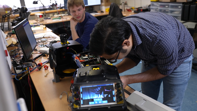
The DiveRay – innovating seafloor mapping
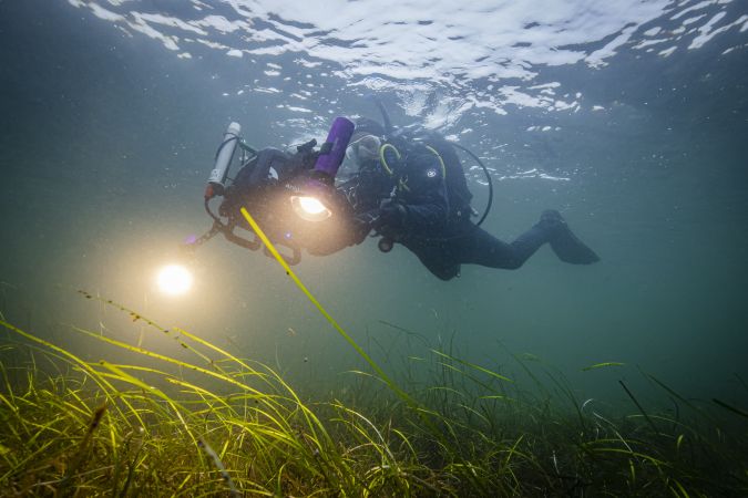
Central to planblue’s seafloor mapping products is the survey data collected with its surveying platform that combines a UHI sensor and a 5.3K RGB camera with planblue’s proprietary underwater navigation solution. The first operational version of this platform, the DiveRay, is diver-operated, with the next, autonomous version planned to be operational later this year. Operating the DiveRay requires no specialized surveying training and can be carried out by the customer. Planning and executing a dive does not require laying down transect lines. Instead, a dive is planned using the FieldGuide (a mobile app shipped pre-installed on a tablet together with the DiveRay), and the DiveRay’s display guides the diver along the planned survey track during the dive. At the end of each dive, the DiveRay connects to the FieldGuide and the survey data is uploaded to planblue’s cloud-based processing facilities. It is also possible to immediately review the quality of the collected data and resurvey if required.
A hyperspectral treasure chest
In addition to the essential data gathered with its RGB camera, the DiveRay’s UHI sensor delivers the real step change in seafloor mapping. It covers the 400–700nm spectral range with 150+ channels. The insights that can be derived from the spectral responses in so many and such narrow spectral bands create a genuine treasure chest of data. So far, a wide variety of hyperspectral sensor applications have demonstrated this ‘above’ water, but underwater the distorting effect of the water column between the sensor and the target poses a significant challenge. Reducing the water column length to close to zero is one way to overcome this challenge. However, this also causes a reduction of the swath width to a scale that may be sufficient for inspecting underwater welds, but is incompatible with the benthic ecosystem mapping envisioned by planblue. A significant amount of the hard work of the past five years went into overcoming this challenge by developing and implementing algorithms to filter out this effect, so that planblue’s DiveRay can now operate at up to 2.5m above the seafloor.
Blue carbon solutions
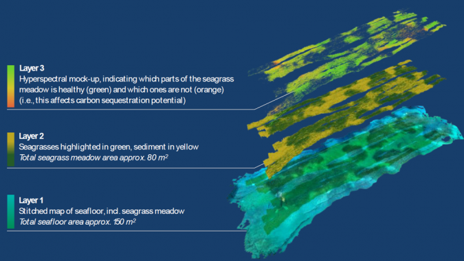
Once planblue had built its first prototype of the DiveRay, it started demonstrating how its survey data could be used in different applications, from detecting plastic waste to mapping coral reef biodiversity to identifying underwater constructions. In parallel, the company’s business team explored the market potential of the wide range of possible applications, and in 2022 the decision was made to focus the first generation of data products on the blue carbon market. These products are focused on mapping the extent and density of seagrass meadows and estimating the amount of carbon stored in them. This information is essential to the quantification and validation of the carbon credits that could be generated by seagrass preservation and restoration projects. Whereas seagrass extent and density can also be derived from hydrographic, aerial and satellite surveys and estimates of the carbon stored are being made based on this data, ground truthing of this remote sensing data remains essential. Besides in situ (or near in situ) observations with at best RGB cameras, ‘coring’ (i.e. digging out sections of the seagrass for lab analysis) is required. It is here that UHI data enables a step change, as insight into the health and photosynthesis levels of the seagrass can be established in a non-destructive manner.
Whereas planblue’s first data products were developed with blue carbon offset projects in mind, they are just as relevant in the traditional coastal management and marine conservation markets. The interest that planblue has received from the geospatial industry is testament to this.

What’s next?
Planblue is continuing the development of its survey platforms and data products along three main axes. Besides the already mentioned development of an autonomous version of the DiveRay, planblue is looking to extend the spatial coverage of its products beyond areas surveyed with its own survey platforms by adding the data fusion with hydrographic, aerial and satellite data to its own processing facilities. At the same time, the company is looking into new products that can be derived from the same UHI data it is already collecting, for instance marine benthic vegetation classification (relevant to biodiversity credits) or plastic waste identification. Planblue’s continued innovation was recognized in January this year when it was selected as top innovator in the Ocean Data Challenge from UpLink, the open innovation platform of the World Economic Forum.
Another next for planblue in 2023 is delivering its first data products to commercial customers and, closely linked to this, a Series A funding round to support the scaling up that commercial operations will require. To date, the company has raised over €7m in grant and equity funding from (among others) renowned VCs and the prestigious European Innovation Council’s Accelerator.
Further reading

Value staying current with hydrography?
Stay on the map with our expertly curated newsletters.
We provide educational insights, industry updates, and inspiring stories from the world of hydrography to help you learn, grow, and navigate your field with confidence. Don't miss out - subscribe today and ensure you're always informed, educated, and inspired by the latest in hydrographic technology and research.
Choose your newsletter(s)


