The First Global Data-driven 3D Ocean Map
With only roughly 10% of oceans having been explored in any detail, the Group on Earth Observations (GEO), an intergovernmental partnership that seeks innovative solutions to global challenges, commissioned a global map of Ecological Marine Units (EMUs). This map will support the wise use of ocean resources and the preservation of environmental resilience by providing a framework for understanding processes and detecting change.
Released in September 2016, the EMU project was created through an innovative public-private partnership led by Esri and the United States Geological Survey (USGS) in collaboration with NatureServe, the Marine Conservation Institute, the University of Auckland (New Zealand), GRID-Arendal (Norway), Duke University, the Woods Hole Oceanographic Institution, the National Institute of Water and Atmospheric Research (NIWA), the United States National Oceanic and Atmospheric Administration (NOAA), and the United States National Aeronautics and Space Administration (NASA).
The EMU project establishes a 3D point mesh framework spanning 52 million points and global measurements of six key variables over a 50-year period of the ocean's water column. The creation of EMUs was a big data project. EMUs are composed of an aggregation and computation on an unprecedented scale. Climatology data was extracted at ¼ degree by ¼ degree (approximately 27 kilometres x 27 kilometres at the equator) intervals at variable depths before being spatially analysed and clustered using a multivariate statistical method and then verified by leading oceanographers.
The result is a standardised, rigorous, and ecologically meaningful set of ocean ecosystem units that may be used as a basemap with other GIS overlays produced by various organisations for climate change impact studies, biodiversity priority setting, economic and social valuation studies, research, and marine spatial planning.
In describing the unique value of EMUs, Dawn Wright, Esri chief scientist who led efforts on the project said, "The strength of EMUs is that they differ from existing maps of marine ecoregions or biogeographic realms by being globally comprehensive, quantitatively data driven, and truly 3D. Rigorous statistical clustering produced 37 physically and chemically distinct volumetric regions where the chemical properties most likely to drive ecosystem responses are readily available to all interested MPAs [marine protected areas], conservation-minded organisations, academic institutions, or citizen scientists. With these insights in hand, individuals can gauge indicators of positive or negative trends and use data to make informed decisions that preserve marine environments."
The authoritative World Ocean Atlas produced by NOAA is the primary data source for EMUs. EMUs are an open, accessible data source that can serve as the basis for further marine spatial research by giving scientists and conservationists better access to knowledge regarding marine ecosystems.
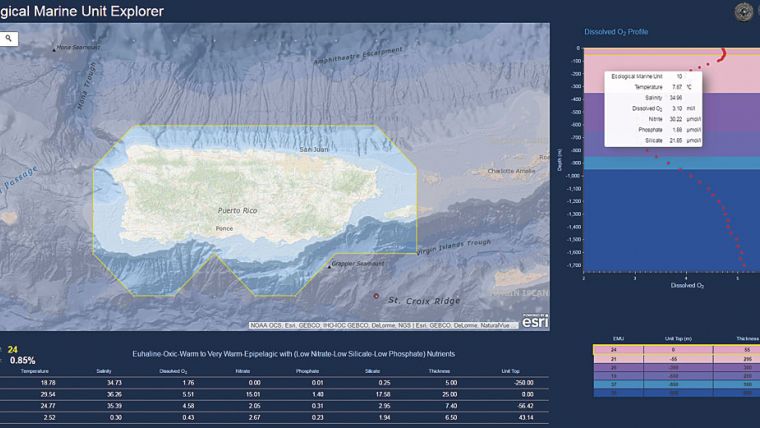
The EMU Explorer apps were developed so the EMUs and the original World Ocean Atlas data could be explored using a web browser or mobile device. Analysis of the entire water column is inherently a 3D application and EMU Explorer apps provide that third dimension, making complex data more understandable and thus making it available for use in the classroom and the field.
By providing ready access to this data, EMU Explorer is a powerful educational tool that can be incorporated into classroom and laboratory exercises, illustrating the connection between human actions and environmental effects.
Although the EMU Explorer apps and EMU layers were made available in the Living Atlas of the World in 2016, the project continues. A global delineation of Ecological Coastal Units (ECUs) at a much finer spatial resolution, as well as global ecological freshwater ecosystems (EFUs), is planned.
The creation of EMUs is a tremendous step toward the goal of not only comprehensively mapping the ocean but also understanding how the earth works. EMU complements the Ecological Land Units (ELUs) released in 2014. ELUs defined and modelled terrestrial ecosystems as unique combinations of bioclimate, landform, geology, and land cover. ELU data can be explored using the Eco Tapestry app in a web browser and as layers in the Living Atlas of the World.

Value staying current with hydrography?
Stay on the map with our expertly curated newsletters.
We provide educational insights, industry updates, and inspiring stories from the world of hydrography to help you learn, grow, and navigate your field with confidence. Don't miss out - subscribe today and ensure you're always informed, educated, and inspired by the latest in hydrographic technology and research.
Choose your newsletter(s)


