Uncovering the secrets of German marine munitions dumpsites
High-performance UXO detection and visualization
In November 2020, a team of researchers from GEOMAR and EGEOS embarked on an unusual round trip across the German Baltic Sea. Their mission was to shed light on the little-known post-war legacy of munitions dumpsites and to improve technologies for their detection.
On a sunny November morning, the scientific team of GEOMAR Helmholtz Centre for Ocean Research Kiel and EGEOS GmbH boarded the research vessel ALKOR. After five long days in quarantine and upon receiving negative Covid-19 test results, it was finally possible to embark on the trip to munitions dumpsites in the German Baltic Sea. The working schedule was tight, and the dry lab was packed with computers for data acquisition and processing. As the research vessel ALKOR left Kiel harbour, the sea was calm and smooth. With the sun reflecting on the water, not many people were aware of the thousands of tons of dumped munitions from World War II (WWII) rusting below the sparkling surface. Nevertheless, the contamination is very real because around 300,000 tons of munitions are located within the German waters of the Baltic Sea.
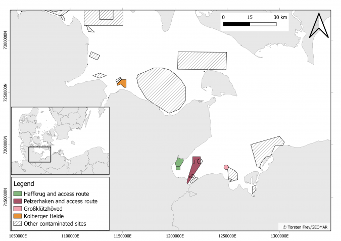
Over the years, numerous research projects have focused on chemical munitions dumpsites in the Baltic Sea, located in the Bornholm, Gotland and Gdansk Deeps. It is only recently that the much larger conventional (i.e. explosive) munitions dumpsites were identified as a potential area of concern. The MineMoni-II trip was conducted as part of the two EU-funded projects – BASTA and ExPloTect – both of which aim to improve detection capabilities. In the case of BASTA, the goal is to make hydrographic and geophysical mapping more efficient by advancing AUV-based data acquisition, applying artificial intelligence and developing data quality factors. The purpose of ExPloTect, on the other hand, is to enable near-real-time detection of dissolved explosive compounds in the water column. During the course of the trip, this toolkit was used in all of the main munitions dumpsites in the German Baltic Sea: Kolberger Heide, Pelzerhaken and Haffkrug (Figure 1).
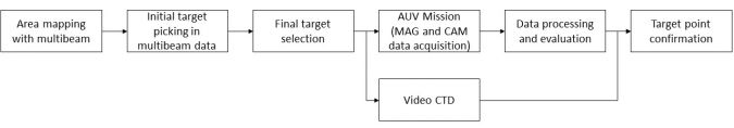
The trip focused on the acquisition of high-resolution multibeam data. Based on this, contact lists, indicating potential munitions objects, were produced immediately on board. Subsequently, the researchers conducted AUV-based surveys to promptly verify whether potential contacts were indeed munitions objects. All of this was supplemented by towed video (TV)-CTD profiles that were used to investigate spectacular hot spots. Figure 2 shows the workflow that led the researchers from an entirely unmapped area to detailed knowledge about individual target points.
The journey started in a known environment
The first research area of the trip was reached only 1.5 hours after the departure from Kiel. The Kolberger Heide is a munitions dumpsite in the outer Kiel Bay, located only 2km offshore. Previous multibeam investigations had already revealed more than 1,000 large munitions objects, such as torpedo heads, ground mines, moored mines and depth charges. Historic research suggests that overall roughly 30,000 tons of legacy munitions are located in the area. It is the best-known dumpsite in Europe and there is still much more to explore.
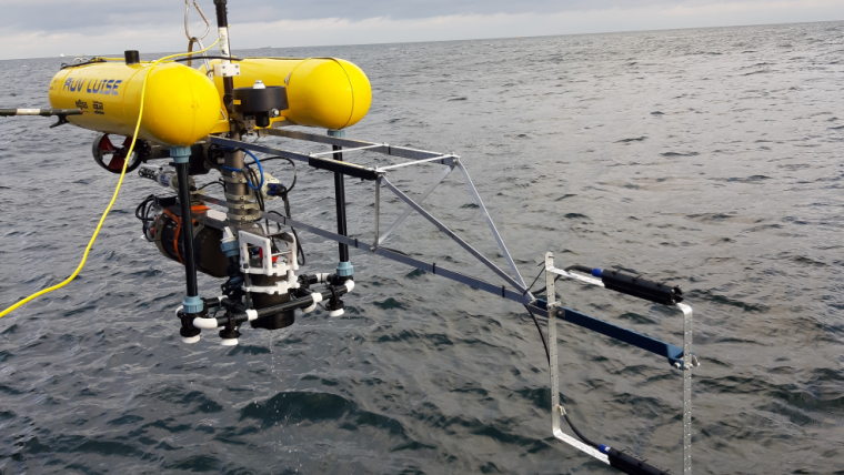
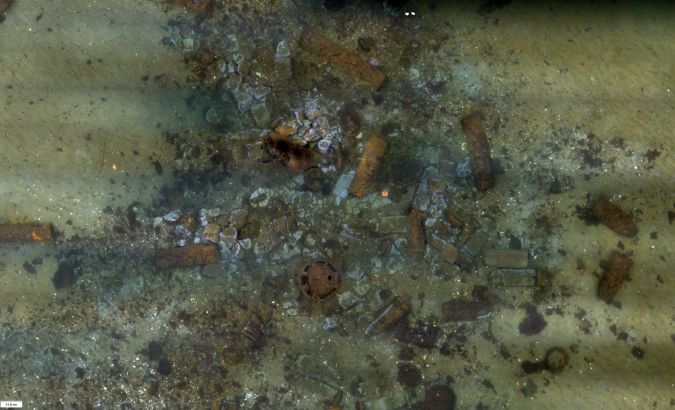
The GIRONA 500 AUVs known as ANTON and LUISE tirelessly mapped and collected magnetic data and underwater images of the seafloor and the munitions objects beneath their tracks. The advantage of these AUVs is their hover capability, which enables movement at a very slow pace close to the seafloor and allows them to turn almost on the spot. These are necessary requirements for dense photographic investigations and high-resolution magnetic surveys. With each AUV dive, around 10,000 images are produced, which are processed to create photomosaics. It takes approximately 20 hours for one mosaic to be generated. For this reason, two PCs, equipped with high-performance GPUs and memory, were running non-stop. The effort was worth the wait and each mosaic revealed a detailed look at the munitions on a millimetre scale (photomosaic resolution: 5mm) (Figure 3).
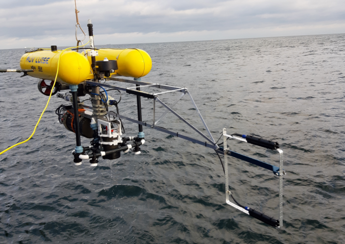
AUV LUISE played an additional role, as it also carried three Sensys 3-components fluxgate magnetometers. The research vessel ALKOR cannot navigate dense profile lines with a line spacing of 1m. The AUV, on the other hand, is an ideal platform for precise navigation and high-resolution magnetic mapping. Once deployed, the AUVs can conduct surveys for several hours. To reduce the magnetic noise that originates from the AUV, GEOMAR constructed a modular system of aluminium poles that could be attached to the AUVs. The magnetic sensors were installed at a lateral distance of 2m to the front of the AUV (Figure 4). Each magnetometer sampled three spatial components at a rate of 200Hz. In this way, it was possible to determine whether a target object was ferromagnetic or not – independently from turbidity of the water or from biofouling which sometimes impedes distinction between, for example, a moored mine and a spherical rock.
Next stop: Lübeck Bay
Once the remaining gaps in the multibeam map of Kolberger Heide had been filled and selected targets had been investigated by AUV missions, the ALKOR was on its way to the next dumpsite. The transits to and between the research sites had been planned along WWII constraint routes. These routes were continuously cleared by German minehunters during the war and were thus the main targets of the British Royal Air Force for remining and bombing. Accordingly, larger numbers of mines and bombs were to be expected along these routes. During transits, water samples were taken with CTD (conductivity, temperature, depth) rosette-mounted Niskin bottles. Similar sampling was conducted in 2018, during the MineMoni-I trip. By resampling at the same locations, the scientists started to create a time series, which will help to obtain a comprehensive understanding of the distribution of explosive compounds (including trinitrotoluene (TNT)) across the German Baltic Sea.
Two additional dumpsites are located in Lübeck Bay (Pelzerhaken and Haffkrug), where 65,000 tons of munitions were dumped after WWII. In the nearby harbours of Neustadt and Travemünde, barges were loaded with train loads of all kinds of conventional munitions. Additionally, over the years, 1,000 tons of blast furnace slag from Travemünde was dumped in the Pelzerhaken area. Detailed bathymetric mapping had already been conducted at both sites in 2018 and in 2020, and data resolutions of 25-50cm were achieved in a water depth of around 20 metres.
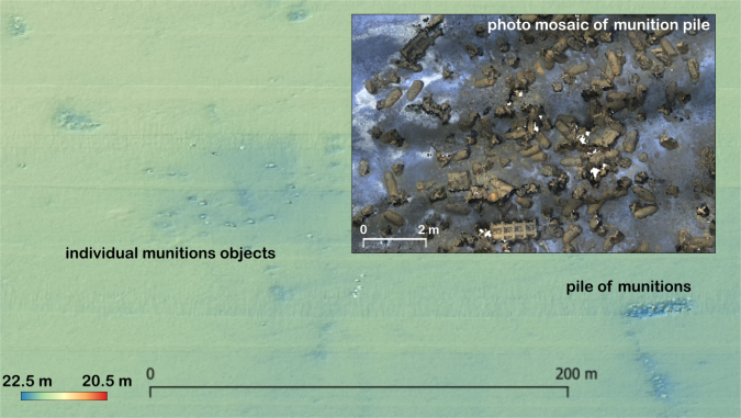
Now that ALKOR had reached Lübeck Bay, multibeam mapping continued, and the scientists gained a full understanding of the spatial extent of the two dumpsites. The high-resolution data was acquired by using a 400kHz RESON T50 multibeam and did not only reveal individual munitions items, but also numerous, at first glance, piles of unidentifiable objects. Owing to high beam density (600 beams/120° swath) and small footprints (0.5x1°), even sedimentary features, such as scours around possible targets, could be observed. Based on this data, a contact list was created and once again the AUVs were deployed for mapping. After the trip, detailed processing and interpretation of the data revealed that the Pelzerhaken area alone contains at least 1,691 individual munitions objects and 127 piles of munitions. The different distribution patterns originate from two very different methods of dumping. One way was to throw the munitions overboard, which led to individual objects sometimes forming lines or other patterns, which now allow the course of a dumping vessel to be retraced. The other method of dumping was to fill barges with munitions and open them once a dedicated site had been reached. This resulted in chaotic piles of both larger objects and boxes containing smaller items. Figure 5 shows both types of patterns in the Pelzerhaken area.
Wreck search in an unmapped area
To make best use of the time, multibeam mapping is always conducted at night. Once the areas in Lübeck Bay had been fully mapped, the researchers spontaneously decided to visit another site that is located 6nm to the east. Historic research indicates that the area called Großklützhöved was used to scuttle entire barges that were loaded with munitions. The prospect of investigating a munitions-filled wreck was exciting for everyone on board and when the first wreck was visible in the data, the entire group quickly gathered around the multibeam station. During the course of the night, two additional wrecks (one of which appeared to be a sailing boat) were found. The next day, the two sunken barges were explored using towed TV-CTD with real-time video stream. One of them had capsized and lost its hazardous cargo during sinking. In the darkness of the Baltic Sea, a pile of grenade cartridges came into view of the TV-CTD LED spots. The photo and video footage combined with high resolution MBES led to a more qualified estimate of the amount of dumped munitions. For the planning of future UXO remediation, it was essential to gain precise knowledge about the number, location and types of munitions.
During MineMoni-II, there was not enough time to map the entire area of Großklützhöved, so the researchers decided that they would come back in 2021 to finish the job. When ALKOR returned to Kiel harbour, the team was able to look back at two very successful weeks. More than 26km² had been mapped to acquire high-resolution multibeam data. Water samples were taken at 77 locations, which means that over 200 syringes with exchanger resin are stored in the freezer, waiting to be analysed with liquid chromatography-mass spectrometry. The AUVs ANTON and LUISE went on 36 missions to acquire tens of thousands of photographs and, finally, 32 TV-CTD profiles were filmed. It will take the researchers a year to evaluate this massive amount of data. By then, they will be ready to embark on MineMoni-III, which is planned for October 2021.
Disclaimer: With the contribution of the European Maritime and Fisheries Fund of the European Union (Grant Agreement No: 863702 (BASTA); 863693 (ExPloTect))

Value staying current with hydrography?
Stay on the map with our expertly curated newsletters.
We provide educational insights, industry updates, and inspiring stories from the world of hydrography to help you learn, grow, and navigate your field with confidence. Don't miss out - subscribe today and ensure you're always informed, educated, and inspired by the latest in hydrographic technology and research.
Choose your newsletter(s)


