120-year maritime mystery of lost steamship unravelled
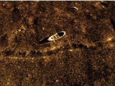
A 120-year-old mystery has been solved with the help of a CSIRO team aboard the RV Investigator. Heritage NSW has announced the discovery of the SS Nemesis, a 73-metre iron-hulled...
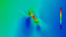
A 120-year-old mystery has been solved with the help of a CSIRO team aboard the RV Investigator. Heritage NSW has announced the discovery of the SS Nemesis, a 73-metre iron-hulled...
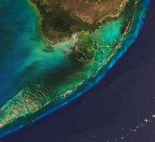
The Florida Department of Environmental Protection has commissioned Woolpert to acquire bathymetric survey data using Lidar technologies to support the Florida Seafloor Mapping Initiative (FSMI) and its mission to produce...

IHO standard S-44 is often used (or misused) to specify the quality of a hydrographic survey. While it is a useful tool, it is easy to misinterpret. One ‘misuse’ is...
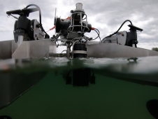
HydroSurv, a prominent provider of electric and hybrid uncrewed surface vessels (USVs), has successfully secured Innovate UK funding to advance the commercialization of an end-to-end seagrass monitoring solution. This endeavour...
A groundbreaking study has unveiled the discovery of an immense coral reef on the bottom of the Atlantic Ocean, marking the largest deep-sea coral reef ever measured. Spanning approximately 26,000...
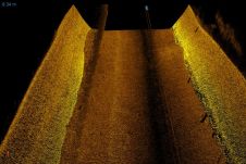
The Hollands Noorderkwartier water board is to improved the Markermeer dikes between Hoorn and Durgerdam in The Netherlands. Dutch firm Boskalis is surveying on land and underwater to draw up a...
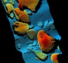
Sonardyne has used 2G Robotics’ underwater laser scanning technology to dynamically scan and map the seabed in Monterey Bay, California, USA. The high-resolution deepwater mapping of Sur Ridge was performed...
Kraken Sonar Systems (Canada) has released SoundPix, designed to work with autonomous underwater vehicles (AUVs), unmanned surface vehicles (USVs) and conventional survey launches. The solution tightly integrates Kraken's real-time synthetic...
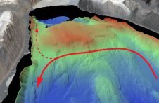
An understanding of the interplay between glaciers and the ocean is needed to improve sea-level rise projections. Seafloor mapping is critical in this pursuit, particularly where the ice sheets of...

A James Cook University researcher in Cairns, Australia, has completed detailed 3D depth maps of Australia’s Coral Sea reefs, shedding new light on the likely distribution of coral diversity and...
This site uses cookies. By continuing to use this website, you agree to our Cookies Policy. Agree