Found 1784 results
Sort by

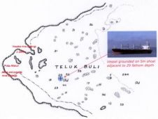
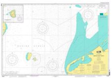
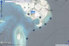
First NOAA Chart Adequacy Workshop

The key objective of the NOAA Chart Adequacy Workshop was to demonstrate techniques to evaluate the suitability of nautical chart products using chart quality information and publicly-available information. The three-day...

Read more

UKHO Expands Brazilian Chart Coverage

As Brazilian waters grow busier, many of Brazil’s port facilities are being modernised and expanded. The UKHO has produced new and updated charts and Port Approach Guides for Brazilian waters...

Read more

Casualties of the Nautical Chart

When ships run aground unexpectedly, the initial presumption is that the vessel has struck an ‘uncharted’ feature. However, in practice this is rarely so. A number of chart-related casualties demonstrate...

Read more

Casualties of the Nautical Chart

When ships run aground unexpectedly the initial presumption is that the vessel has struck an ‘uncharted’ feature. In practice this is rarely so. This article reviews a number of chart-related...

Read more

Nautical Chart for Arctic Updated

NOAA Office of Coast Survey has released a new nautical chart for the Arctic, which will help mariners navigate the Bering Strait. Chart 16190 (Bering Strait North) incorporates precise depth...

Read more

Chart Distribution Contracts for EVG

East View Geospatial (EVG, USA) has entered into chart distribution contracts with Land Information New Zealand (LINZ) and the U.S. National Oceanic and Atmospheric Administration (NOAA). These charts are suitable...

Read more