CARIS Announces ‘Ping to Chart’ Workshop Series
CARIS has announced a workshop series called Ping to Chart World Tour 2006. This World Tour will be a unique series of five-day hands-on CARIS software training workshops that cover...
CARIS has announced a workshop series called Ping to Chart World Tour 2006. This World Tour will be a unique series of five-day hands-on CARIS software training workshops that cover...
CARIS has announced a workshop series called Ping to Chart World Tour 2006. This World Tour will be a unique series of five-day hands-on CARIS software training workshops that cover...
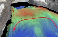
An understanding of the interplay between glaciers and the ocean is needed to improve sea-level rise projections. Seafloor mapping is critical in this pursuit, particularly where the ice sheets of...
The position of bathymetric sensors in hydrographic education is beyond discussion, as bathymetry is, was and will continue to be the bread and butter of the hydrographic surveyor. Bathymetric sensors...
The UK Hydrographic Office (UKHO) has announced that two ADMIRALTY distributors are now approved providers of ADMIRALTY Vector Chart Service (AVCS) Online, the shore-based version of the maritime chart service....
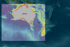
More than 1,500 individual seabed surveys have been combined to give sectors such as marine park management and offshore renewable industries – as well as storm surge modellers – a...
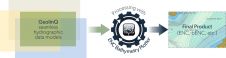
IntellinQ, The Netherlands, and SevenCs, Germany, have recently joined forces and signed a cooperation agreement in order to develop, promote and support an integrated solution for nautical chart production. The...

Following up on Coast Survey’s visit to Havana, Cuba, spring 2015, Cuban hydrographic officials travelled to Maryland, USA on 15-17 December 2015, to meet with NOAA National Ocean Service (NOS)...
On U.S. coastal nautical charts, the areas closest to the shore, shoals and rocks generally do not have updated depth measurements. In many areas, safety concerns prohibit the use of...
S-101 is the new product specification for Electronic Navigational Chart (ENC) datasets based on the overarching S-100 framework standard of the International Hydrographic Organisation (IHO). The development of S-101 is...
This site uses cookies. By continuing to use this website, you agree to our Cookies Policy. Agree