Remote hydrography and regulation: mission impossible?
The development of unmanned and autonomous surface vehicles in recent years has triggered a new era in civilian and military maritime operations. One of the applications that is likely to...

The development of unmanned and autonomous surface vehicles in recent years has triggered a new era in civilian and military maritime operations. One of the applications that is likely to...
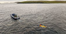
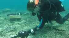
The National Oceanography Centre (NOC), working with the University of Southampton and the Department for Environment, Food and Rural Affairs (Defra), recently completed a Fully Autonomous Marine Protected Area Seafloor...
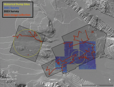
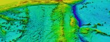
In a second seafloor survey off the Southern California coast, researchers from UC San Diego’s Scripps Institution of Oceanography uncovered a staggering 350 square kilometres of discarded military munitions. The April...
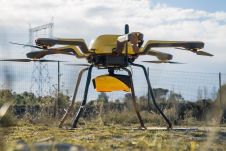
YellowScan, a familiar name in the mapping and land surveying realm, is making a noteworthy entrance in the hydrographic sector with the introduction of its pioneering UAV-based bathymetric Lidar solution....
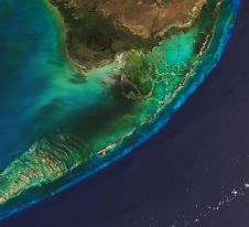
The Florida Department of Environmental Protection has commissioned Woolpert to acquire bathymetric survey data using Lidar technologies to support the Florida Seafloor Mapping Initiative (FSMI) and its mission to produce...

Ocean data has a vital but underappreciated role to play as an enabler in shipping’s energy transition. In particular, it can help to unlock the short-term carbon savings that will...
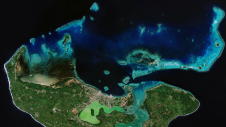
Coastal zones, situated at the intersection of land and ocean, hold immense social, economic and ecological significance. Currently, nearly 40% of the global population resides within 100km of the coast,...
ARGANS, a leading Earth observation company, has contributed a significant dataset of 8,000 square kilometres to The Nippon Foundation-GEBCO Seabed 2030 Project – the project seeking to inspire the complete...
Researchers at the Heron Island Research Station in Australia are using a Nortek velocimeter to determine how much hydrodynamic energy it takes to move “coral rubble”, the skeletons of corals...
Aspect Land & Hydrographic Surveys Ltd is one of the leading independent coastal survey companies in the UK, with extensive experience and a proven track record in providing high-resolution hydrographic,...
This site uses cookies. By continuing to use this website, you agree to our Cookies Policy. Agree