Oceans of Colour
Natural water colour measurements are based on multi- and hyper-spectral measurements performed in the field and from space. A simpler approach to determine the colour of natural waters is by...
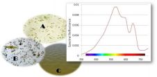
Natural water colour measurements are based on multi- and hyper-spectral measurements performed in the field and from space. A simpler approach to determine the colour of natural waters is by...
The North Sea Canal connects the Port of Amsterdam with the sea. The two breakwaters at the mouth of the harbour in IJmuiden, The Netherlands, are usually monitored on displacement...
A consortium consisting of Royal Boskalis Westminster N.V. (Boskalis), Van Oord, NMDC (Abu Dhabi) and Jan de Nul (Belgium) has acquired a contract from the Suez Canal Authorities, in connection...
ChartWorld, Germany, offers the OceanWise Marine Themes dataset combining the fragmented features of traditional nautical charting merged into an almost seamless marine map. The resulting data is more beneficial and...
The Coastal Zone Mapping and Imaging Lidar (CZMIL) won a Geospatial World Technology Innovation Award at the Geospatial World Forum on 8 May 2014, in Geneva, Switzerland. It earned recognition...

The BBC has filmed a report on Teamsurv and how OceanWise will potentially use Teamsurv data to improve OceanWise’s Seabed Digital Elevation Model (DEM). Large parts of the seas around...

Workshop on Belgian Tidal Energy Atoll and AGM On 19 March, the Hydrographic Society Benelux organised a workshop on the creation of a tidal energy atoll offshore Belgium in the...
Independent marine data management and publishing specialist, OceanWise Ltd, UK, has established off-the-shelf marine mapping datasets for demanding applications. The Marine Themes vector mapping coverage has been extended for a...
Proteus FZC, UAE, has teamed with TCarta Marine, USA, to offer complete bathymetric data sets from the shallow near-shore coastal zone out to the continental shelf. Depending on water conditions,...
The latest phase of the hydrography part of the European Marine Observation and Data Network (EMODNet) has commenced with a meeting in Lisbon, Portugal, hosted by the Portuguese Marine and...
This site uses cookies. By continuing to use this website, you agree to our Cookies Policy. Agree