Bluesky Adds to Flood Risk Modelling Software
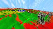
The latest aerial photography and detailed earth surface models from Bluesky are being used for demonstration in a software package developed to assess the risk and impact of flooding. To...

The latest aerial photography and detailed earth surface models from Bluesky are being used for demonstration in a software package developed to assess the risk and impact of flooding. To...
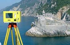
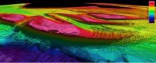
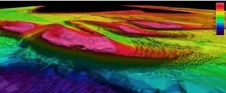
When surveying the coastline, the integration of bathymetric (below sea level) and laser scanning (above sea level) data causes problems due to the different imaging properties. However, by ensuring that...
IVS 3D announced its partnership with Geomatics Data Solutions to provide sales, support, and training to Fledermaus clients located on the western coast of North America. With over 25 years...
Hydrographic Society Russia HSR Honorary Member Jubilee It seems as though it was only recently that HSR members and hydrographers of Russia marked the 80-year birthday of honorary member of...
The development of deepwater and ultra-deepwater subsea fields is one of the greatest challenges facing the offshore oil and gas industry today. The depths involved present a host of engineering...
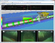
NaviModel software for ocean mapping, data analysis and interpretation provides intuitive 3D visualiasation of infinite survey data sets by import of multiple data formats and sources using user-defined templates. NaviModel...

Andy Hill is key-note speaker at OI 10 in London and convening the Hydrography and Geophysics track of the conference. As Marine Geohazards Technical Authority at BP he states that...
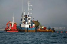
Swathe Services was recently commissioned by Falmouth Divers to assist on a 4km submarine power cable installation to a remote island community on behalf of one of their clients in...
TruDepth Seamless Layer of UK Bathymetry TruDepth survey bathymetry products represent a collection of Digital Terrain Model (DTM) tiles. The models are based on the best available survey data from...
SeaZone can provide full UK coastal coverage of TruDepth Grids. SeaZone TruDepth Grids is a solution which delivers the best available information on water depth around the UK. The latest...
This site uses cookies. By continuing to use this website, you agree to our Cookies Policy. Agree