A Challenge in the Arctic
In 1997, the Russian Federation (RF) ratified the United Nations Convention on the Law of the Sea and started the explorations intended to specify the outer limit of the continental...
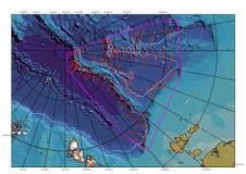
In 1997, the Russian Federation (RF) ratified the United Nations Convention on the Law of the Sea and started the explorations intended to specify the outer limit of the continental...
Soundings and contours are the only official way data producers can push bathymetric information to the wide hydrographic community. The introduction of the S-102 standard for bathymetry will enable many...
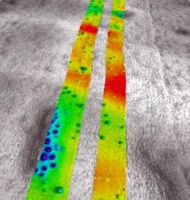
The planned widening of the Dutch Maas river (Meuse) represents a landscape correction that will prevent future flooding. Gravel barriers are being prepared in order to buffer any additional flow....
NaviModel 3.2, Eiva's DTM modelling package, has been released in a full 64 bit version. This release takes full advantage of all hardware, including parallel processing and additional memory. This...
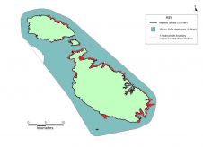
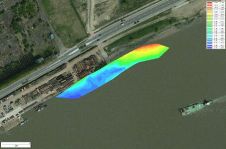
Malta, the smallest European Union state, has carried out a country-wide hydrographic survey which was initiated in Q1 2012 and completed in Q4 of the same year. Aimed at acquiring...
In the last few decades, substantial efforts have been made to improve and facilitate the way hydrographic data is obtained. One technology is the EdgeTech 4600, an interferometric phase difference...
Designing offshore engineering facilities requires large amounts of information. To acquire it, suites of engineering and geophysical surveys are run, which as a rule include such techniques of seabed and...
Eye4Software’s hydrographic survey package, Hydromagic version 5.1, has been released. The software maps the bottom of a river, pond or ocean in 3D by using a (D)GPS or RTK positioning...

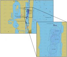
RESON is providing a SeaBat 7125 sonar system for a new breakwater mapping system GEOSUB 3DTM developed by the company MESURIS in France. It is a high-resolution 3D real-time bathymetric...
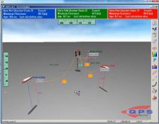
The recent release of QPS QINSy (8.10.2013.10.10.1) includes real-time functionality for using advanced catenary tools to compute the tow cables and anchor chains involved in a rig move using a...
This site uses cookies. By continuing to use this website, you agree to our Cookies Policy. Agree