The Seabed Survey Data Model
Exploration and Production (E&P) companies spend millions of dollars every year undertaking seabed surveys to acquire data to help in many exploration and production activities such as: determining potential well...
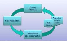
Exploration and Production (E&P) companies spend millions of dollars every year undertaking seabed surveys to acquire data to help in many exploration and production activities such as: determining potential well...
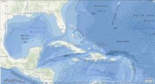
Esri has created and released a new, comprehensive map of the world's oceans and coastal areas. The Ocean Basemap is now available as a cached map service in ArcGIS Online....
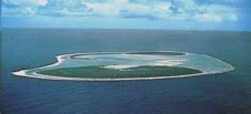
At the Eye on Earth Summit in Abu Dhabi last week, the Geographic Information System (GIS) software company Esri committed to building a database for the Cook Islands Marine Park...

Esri has created a mash-up of the hurricane Irene. The data is displayed close to live and displays various aspects of the weather including storm surges, active hurricanes and precipitation....
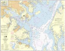
The National Oceanic and Atmospheric Administration (NOAA, USA) has implemented a new nautical charting system based on Esri GIS technology to produce more navigational products than ever before without increasing...

OpenOceans Global is a non-profit, non-advocacy organisation dedicated to ‘Linking People to the World’s Oceans’ through sharing information that will result in more informed decisions. The organisation envisions a human...
Esri ArcGIS software can now be used to visualise S-57 data with the symbology that the International Hydrographic Organization (IHO) requires. The Esri S-57 Viewer can be downloaded free of...
Esri, USA, has released a solution to support users in port management, maritime transport, coastal management, offshore energy, nautical chart production, and maritime defence. ArcGIS for Maritime: Charting and ArcGIS...
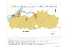
Safety of navigation on inland waterways is as important as in maritime waters. To guarantee this, Electronic Navigational Charts (ENCs) have now been produced for several years. As inland waterways...
The University of California, Santa Barbara (UCSB), USA, has officially launched SeaSketch, an ocean planning tool supported by Esri, USA. Conservationists, planners and ocean resource managers are now able to...
This site uses cookies. By continuing to use this website, you agree to our Cookies Policy. Agree