Remote hydrography and regulation: mission impossible?
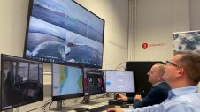
The development of unmanned and autonomous surface vehicles in recent years has triggered a new era in civilian and military maritime operations. One of the applications that is likely to...

The development of unmanned and autonomous surface vehicles in recent years has triggered a new era in civilian and military maritime operations. One of the applications that is likely to...

Ocean data has a vital but underappreciated role to play as an enabler in shipping’s energy transition. In particular, it can help to unlock the short-term carbon savings that will...
Anschütz, a leading expert in navigation and bridge systems, is making significant strides in the development of autonomous and onboard assistance systems for ships. As part of the Clean Autonomous...
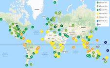
FarSounder is partnering with The Nippon Foundation-GEBCO Seabed 2030 Project to work together to advance the collective understanding of the ocean floor in pursuit of the complete map of the...
On 24 January 2023, the European Union declared the Galileo High Accuracy Service (HAS) operational for testing, and it is scheduled to become fully operational in 2024. This free signal adds...

Experts are extremely concerned about the temperature of the Pacific Ocean, as the sea surface temperature this year was the warmest since satellite measurements began. This can have major consequences: for...
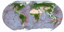
Delving into the mysteries of the planet’s final frontier – the ocean – has long captivated human curiosity, with the origins of ocean exploration dating back to 5,000 BC. But...
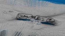
Some 290 shipwrecks lie in the Belgian part of the North Sea alone, with probably more than 1,000 in the entire North Sea, many of them silent witnesses to the...

SatLab HydroBoat 1200—an embodiment of compactness and ease, tailored for seamless operation across a spectrum of equipment. Enhanced by professional CFD technology, its stability finds new heights. Melded with high-precision...
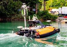
Surveying bodies of water accurately is a challenging task, while authorities and port operators are required to provide up-to-date maps of riverbeds and port facilities. Until now, this has required...
This site uses cookies. By continuing to use this website, you agree to our Cookies Policy. Agree