Russian Survey Vessel Explores 14,000km Cable Route Across Arctic Seabed
On 6 August 2020, the Professor Logachev survey ship set out from Kirkenes, Norway on course for Russian Arctic waters. Over the next three months, the ship and its crew...

On 6 August 2020, the Professor Logachev survey ship set out from Kirkenes, Norway on course for Russian Arctic waters. Over the next three months, the ship and its crew...

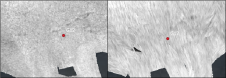
OceanWise has announced that, as of 1 November 2021, the RSOBIA toolbar is available free of charge. The software tool, which takes raster imagery and segments the data into geographic...
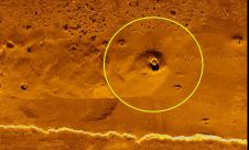
The practice of identifying and monitoring an area's physical features by measuring its reflected and emitted radiation from a distance is known as remote sensing (typically from satellite or aircraft). Researchers can "sense" facts about the Earth by using special cameras to acquire remotely sensed photos. Remote sensing is a fascinating field that revolves around the acquisition of Earth-related information without direct physical contact. It typically yields either point cloud data or imagery, both of which...
The health of our oceans and the health of our planet are one and the same. Yet the link between how much we know about this environment and how we...
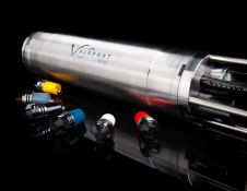
Ocean Business 21 was the launch venue for Valeport’s new Bathy2, presented as an “exciting evolution in the collection of bathymetric data.” It was shown for the first time, ahead...
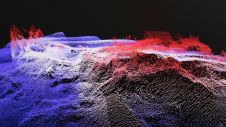
The multibeam echosounder (MBES) is used for various purposes, and MBES systems have become the standard instrument for bathymetric determination. However, new developments mean that MBES systems are no longer...
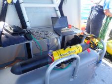
Seatronics, the lead brand within Acteon’s electronics and tooling segment, has entered a global distribution agreement with French manufacturer RTSYS for its autonomous underwater vehicles (AUV) and passive acoustic monitoring...
Kongsberg Maritime has announced the launch of Blue Insight, a powerful, cloud-based digital toolbox to enable high-end collection, visualization, contextualization, management and distribution of ocean data. Focusing on marine and...

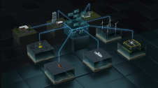
Machine learning is currently experiencing a surge of interest. Of course, what first come to mind are self-driving cars, face recognition and internet algorithms. However, while these are great examples...
EdgeTech – a leading company in high-resolution sonar imaging systems and underwater technology – has recently introduced an innovative and new method to provide nadir gap coverage on the EdgeTech...
This site uses cookies. By continuing to use this website, you agree to our Cookies Policy. Agree