Sir, Can I Use My ECDIS Now?
July 2002 signalled a significant milestone in the long, tortuous life of ECDIS. It was the month that ECDIS was formally recognised (and specifically mentioned) in SOLAS Chapter V. It...
July 2002 signalled a significant milestone in the long, tortuous life of ECDIS. It was the month that ECDIS was formally recognised (and specifically mentioned) in SOLAS Chapter V. It...
The champions of ECDIS (Electronic Chart Display & Information Systems) correctly claim that, when properly understood, its use increases the safety of navigation. Its critics point out that it is...
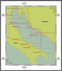
From the quality perspective, an electronic navigational chart (ENC) as a product is more demanding than its paper predecessor. Quality control and quality assurance of an ENC is a complex...

Among the most exciting advances in remote sensing are the innovations being made in multi-sensor data fusion. This can exponentially increase both the quality and quantity of information in the...
Safe Software has released FME 2008. The release includes the unveiling of FME Server, a scalable solution for data transformation and distribution, as well as a new version of FME...
Safe Softwar's FME spatial ETL (extract, transform, and load) platform will support the spatial data capabilities made available in the SQL Server 2008 November Community Technology Preview (CTP). In the...
Myriax has released its Eonfusion product. Eonfusion is a unique application that provides 4D analysis and visualisation of time-varying spatial data. It allows users to streamline the integration of large...
The United Kingdom Hydrographic Office (UKHO) has launched the Admiralty Vector Chart Service (AVCS). AVCS will provide the international mariner with an integrated global set of Electronic Navigational Charts (ENCs)...

Standardisation of hydrographic methods and the provision of information is a fundamental part of achieving the IHO objectives. The Organization began developing standards and guidelines intended for use by the...
Electronic Navigational Charts (ENCs) are produced to the hydrographic standard S57 ed 3. In order to enjoy official status as ENCs they must accord with the product specification and be...
This site uses cookies. By continuing to use this website, you agree to our Cookies Policy. Agree