OpenSeaMap – the Free Nautical Chart
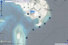
Nautical charts are expensive, and in many countries data are not always up to date. OpenSeaMap is an alternative solution which is free for anybody to use worldwide. Following the...
Nautical charts are expensive, and in many countries data are not always up to date. OpenSeaMap is an alternative solution which is free for anybody to use worldwide. Following the...
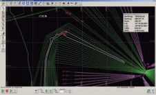
Quetzal Desenvolvimento de Sistemas Digitais in Rio de Janeiro, Brazil, develops software solutions relating to navigation, pipe laying, surveying and data-logging for the offshore and naval industry. Since 2009, Quetzal...
Esri, USA, has released a solution to support users in port management, maritime transport, coastal management, offshore energy, nautical chart production, and maritime defence. ArcGIS for Maritime: Charting and ArcGIS...

OceanWise invites expressions of interest from suppliers of geographic information wishing to market and distribute marine and coastal data to the engineering, environmental and location-based services sectors. As its twelve-month...

At a flooding conference held in the Danish Parliament on 3rd February 2012, the Danish Minister for the Environment launched a nationwide online interactive tool to map the risk of...
This winter, NOAA will begin a year-long survey of the sea floor in the Port of Houston and Galveston Bay navigational areas, USA, to aid efforts to bring more trade,...
Hydrographic data is at the core of ECDIS. The International Hydrographic Organization (IHO) is of the opinion that the quantity and coverage of good hydrographic data around the world is...

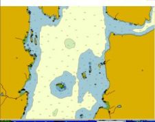
The Amazon is the world’s largest river system. With more than 50,000km of navigable waters, ocean-going vessels are able to transit almost 6,000km from its mouth in the Atlantic Ocean...
iXSurvey has recently purchased LizardTech’s GeoExpress software. The company acquires hydrographic and geophysical data which is crucial for both offshore and coastal engineering projects. GeoExpress is now being used to...
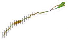
Soundings and contours are the only official way data producers can push bathymetric information to the wide hydrographic community. The introduction of the S-102 standard for bathymetry will enable many...
This site uses cookies. By continuing to use this website, you agree to our Cookies Policy. Agree