Hydro International #1- 2024
In a roundup of the hydrographic industry’s latest developments in multibeam echosounding technology, this issue dives into the depths of hydrographic survey data, uncovering advanced techniques and tools that are...
In a roundup of the hydrographic industry’s latest developments in multibeam echosounding technology, this issue dives into the depths of hydrographic survey data, uncovering advanced techniques and tools that are...
The offshore wind industry knows it can do better. While its potential is undeniable, challenges remain and acknowledging its shortcomings is crucial for progress. Oceanology International 2024 aims to confront...
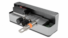
EM 2042 Multibeam Echosounder Small in size, but powerful in potential, the EM 2042 Multibeam Echosounder is efficient, light, robust and reliable: delivering high-density, high-resolution, clean data in the most demanding marine environments. With...

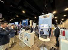
Leading professionals from the ocean science and technology industries will gather at Oceanology International in London from 12–14 March. Oceanology International has announced a captivating lineup of esteemed industry leaders and...
RIEGL has announced the launch of two innovative topobathymetric scanners. These advancements mark a shift towards enhanced efficiency and precision in data collection across land and water interfaces. The RIEGL...
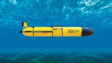
Teledyne Webb Research, a leading innovator in oceanographic research, has launched the Slocum Sentinel Glider, poised to make its debut at Oceanology International (Oi) in London in March 2024. The...
A 120-year-old mystery has been solved with the help of a CSIRO team aboard the RV Investigator. Heritage NSW has announced the discovery of the SS Nemesis, a 73-metre iron-hulled...

IHO standard S-44 is often used (or misused) to specify the quality of a hydrographic survey. While it is a useful tool, it is easy to misinterpret. One ‘misuse’ is...
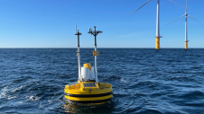
HydroSurv, a prominent provider of electric and hybrid uncrewed surface vessels (USVs), has successfully secured Innovate UK funding to advance the commercialization of an end-to-end seagrass monitoring solution. This endeavour...

The Danish Geodata Agency, alongside several collaborators, is currently conducting trials on the latest iteration of navigational charts in the Baltic Sea region. This initiative forms part of an EU-funded...
This site uses cookies. By continuing to use this website, you agree to our Cookies Policy. Agree