Observing the ocean together
Collaborating and coordinating are two very important tasks of EuroGOOS, the European Global Ocean Observing System, located in Brussels. The member organizations work together to share ocean observation data and...

Collaborating and coordinating are two very important tasks of EuroGOOS, the European Global Ocean Observing System, located in Brussels. The member organizations work together to share ocean observation data and...

SEA-KIT International, a leading designer and builder of uncrewed surface vessels (USVs), achieved a significant milestone in 2021 when it received the first-ever Unmanned Marine Systems (UMS) certificate from Lloyd’s...

VideoRay, a leading manufacturer of portable underwater robots, has announced the launch of its new vehicle called Ally. Ally is the newest member of the Mission Specialist family, joining the...

IHO standard S-44 is often used (or misused) to specify the quality of a hydrographic survey. While it is a useful tool, it is easy to misinterpret. One ‘misuse’ is...

Geospatial cloud specialist north.io has announced it aims to revolutionize the modelling, collection and processing of ocean data using NVIDIA technologies. According to Jann Wendt, CEO, north.io, the synergy between...

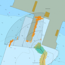
Corey Goodrich is a majority owner and managing partner of TCarta, a small Denver, CO-based business specializing in satellite-based innovative technologies for improved modelling and understanding of shallow water and...

By harnessing capabilities of advanced satellite technology and ever-evolving data analysis, satellite-based mapping (including satellite-derived bathymetry, SDB) offers an efficient, extensible and cost-effective method for mapping water properties, underwater topography...

EuroGOOS has been endorsed as an implementing partner of the UN Ocean Decade. As a designated partner, EuroGOOS is set to be fully committed to advancing ocean research, observation and...
The latest release of FarSounder’s SonaSoft software has been upgraded to be compatible with S-57 and S-63 Charts. Anyone using these chart formats is now able to overlay real-time data...

Kongsberg Discovery commemorates 30 years of inertial navigation excellence with the launch of Seapath 385. Unveiled at Oceanology International in London, this innovative system integrates new hardware and advanced navigation...
This site uses cookies. By continuing to use this website, you agree to our Cookies Policy. Agree