Helzel Messtechnik GmbH
Reliable high-quality ocean current, wave and wind data in real-time. HELZEL Messtechnik specialises in HF systems and is the manufacturer of the unique Ocean Radar 'WERA', providing high-quality Ocean Current...

Reliable high-quality ocean current, wave and wind data in real-time. HELZEL Messtechnik specialises in HF systems and is the manufacturer of the unique Ocean Radar 'WERA', providing high-quality Ocean Current...

Hemisphere GNSS has introduced the RTK-enabled Vector V320 GNSS Compass. The Vector V320 smart antenna supports multi-frequency GPS, GLONASS, Galileo (future firmware upgrade required) and BeiDou. Designed for the professional...

Mariners rely on many sources of information during daily operations to ensure their safety at sea; nautical charts and weather information are critical and can sometimes lead to life-changing decisions. The ways in which navigation and weather data are created, disseminated and displayed by mariners are drastically different, having made integration of this information difficult in the past. NOAA and the Brazilian Navy Hydrographic Center are working together to develop a new methodology and international standard that will allow weather forecasts and analyses to be displayed like navigational charts: as an overlay on Electronic Chart Display and Information Systems (ECDIS). Mariners rely on many sources of information during daily operations to ensure their safety at sea. Nautical charts and weather information are critical and can sometimes lead to life-changing decisions....
OceanWise, UK, has released free, interactive Marine Mapping product demonstrators. Built using OpenLayers, the demos allow the user to pan around a defined area and get a feel for different...
NOAA is one of the bigger organisations in the world that has surveying and charting in its portfolio. It’s an immense task as the USA has about 95,000 miles of coastline, important ports and a wide range of users – from recreational boaters to the biggest container vessels and tankers. The country also has to deal with environmental disasters like hurricanes and oil spills. NOAA is undergoing changes as the chart portfolio is ‘going digital’ and new initiatives such as using Maritime Autonomous Systems (MAS) for surveys. Hydro International interviews Capt Shep Smith, who generously gave an insight behind the scenes. NOAA is one of the bigger organisations in the world that has surveying and charting in its portfolio. It’s an immense task as the USA has about 95,000 miles of...
The key objective of the NOAA Chart Adequacy Workshop was to demonstrate techniques to evaluate the suitability of nautical chart products using chart quality information and publicly-available information. The three-day...
Gabri S.r.l. is a company located in Genova, Italy, whose trade is in the AUV market. The company aims to set a new quality standard for the autonomous underwater vehicle...
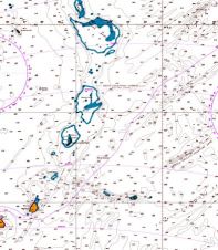
During Leg 2 of the Volvo Ocean Race from Cape Town to Abu Dhabi, Team Vestas Wind ran aground on the night of 29 November 2014 on the Cargados Carajos...

In 2014, tsunami waves originating off the coast of Chile were successfully detected near Japan, where EvoLogics' modems enabled acoustic communication between JAMSTEC’s Vector Tsunameter on the seafloor and the...
People travelled from all parts of the world to attend the HYPACK 2015 Training Event in San Antonio, Texas, USA. With over 250 attendees, 25 exhibitors and 6,000 remote viewers...
This site uses cookies. By continuing to use this website, you agree to our Cookies Policy. Agree