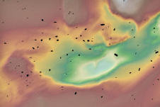
Airborne Lidar bathymetry in close up
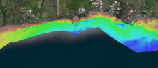
RIEGL tested the performance of its topobathymetric airborne laser scanning system in a transition zone context along the French Mediterranean coast. Initially planned as a UAV survey, tests were conducted...
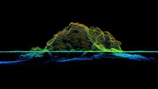
RIEGL tested the performance of its topobathymetric airborne laser scanning system in a transition zone context along the French Mediterranean coast. Initially planned as a UAV survey, tests were conducted...
As the demand for elevation data continues to rise, it is important that users match the level of reliability, accuracy and resolution of the data to their specific application to...
This article presents a participative geomatics project with the goal of increasing southern Québec’s coastal communities’ ability to map and monitor changes in their coastal environment. Capacity-building and empowerment using...
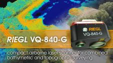
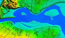
The RIEGL VQ-840-G is a compact Topo-Bathymetric Airborne Laser Scanner especially suited for coastline and shallow water mapping providing more than 2 Secchi depths water penetration. The scanner provides high...
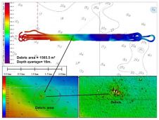
Sriwijaya Air Flight 182 was an Indonesian domestic flight from Soekarno-Hatta International Airport in Jakarta to Pontianak, Indonesia. On Saturday 9 January 2021, the Boeing 737 crashed into the waters...
Archaeologists have long been interested in shipwrecks. These sites can tell us about ancient transportation and trading routes, technological innovations and cultural exchanges over thousands of years. Documenting shipwrecks can...
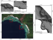
The accuracy of coastline data in Indonesia could be much improved by making use of Lidar bathymetry technology. In this article, the authors describe how Lidar bathymetry survey techniques were...
Woolpert has been awarded a task order under the National Oceanic and Atmospheric Administration’s Shoreline Mapping Services Contract to provide topographic and bathymetric Lidar data and imagery for islands in...
Bluesky International will use aircraft-mounted Lidar sensors to create a highly detailed 3D map of the whole of the Northern Ireland coastline. The Bluesky data will form part of the...
Fugro has won a contract to capture bathymetric Lidar of Northern Ireland’s coastline as part of a project from the Department of Agriculture, Environment and Rural Affairs (DAERA) to create...
This site uses cookies. By continuing to use this website, you agree to our Cookies Policy. Agree