Video Introducing EMODnet
The European Marine Data and Observation Network (EMODnet) consists of more than 100 organisations assembling marine data, products and metadata to make these fragmented resources more available to public and...
The European Marine Data and Observation Network (EMODnet) consists of more than 100 organisations assembling marine data, products and metadata to make these fragmented resources more available to public and...
The International Hydrographic Organization celebrates World Hydrography Day every year on 21 June. World Hydrography Day is an opportunity to increase public awareness of the vital role that hydrography plays...
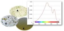
Natural water colour measurements are based on multi- and hyper-spectral measurements performed in the field and from space. A simpler approach to determine the colour of natural waters is by...
UK-based OceanWise and the United Kingdom Hydrographic Office (UKHO) hosted an Open Forum on Marine Spatial Data Infrastructure (MSDI) followed by the 6th International Hydrographic Organisation’s MSDI Working Group (IHO...
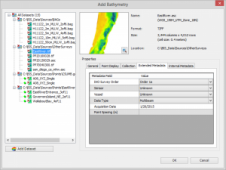
Esri, headquartered in the USA, has released ArcGIS for Maritime: Bathymetry 10.3, adding features such as the support for point feature classes. Some of the added options are: Custom spatial...
In this internet age, crowdsourcing is fast providing practical contributions to our understanding of the world around us. Whether it be software developed in an open-source environment, inputs from ‘those...
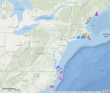
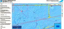
The NOAA Coast Survey is posting its three-year survey plans and making them publicly available at the Planned NOAA Hydrographic Survey Areas (2015-2017) in ArcGIS Online. In addition to seeing...

Just before the INSPIRE Conference 2014 in Aalborg, Denmark, about 30 people sat together on board the Barkentina LOA, a beautiful tall ship. They discussed how to make better use...
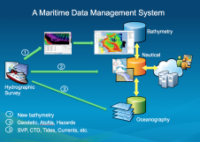
Traditionally, hydrographic data was used mainly for nautical charts. Hydrographic surveys are costly, and data should be used beyond navigation. Some have developed centralised hydrographic databases, but their only purpose...
The USGS, USA, has released a web-based geospatial service known as the Hydrography Event Management (HEM) tool. It allows users to create, edit and display geospatial markers, called Events, that...
This site uses cookies. By continuing to use this website, you agree to our Cookies Policy. Agree