120-year maritime mystery of lost steamship unravelled
A 120-year-old mystery has been solved with the help of a CSIRO team aboard the RV Investigator. Heritage NSW has announced the discovery of the SS Nemesis, a 73-metre iron-hulled...
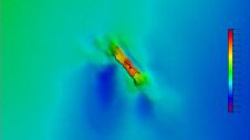
A 120-year-old mystery has been solved with the help of a CSIRO team aboard the RV Investigator. Heritage NSW has announced the discovery of the SS Nemesis, a 73-metre iron-hulled...
The Florida Department of Environmental Protection has commissioned Woolpert to acquire bathymetric survey data using Lidar technologies to support the Florida Seafloor Mapping Initiative (FSMI) and its mission to produce...
Applanix introduced today the latest LANDMark Marine mobile mapping solution, which enables the creation of seamless models of near shore environments by providing a georeferenced point cloud which integrates with...
Positioning Resources introduces MobileMapper CE, the next generation handheld GPS mobile mapping device from Thales Navigation. The new MobileMapper CE offers features like sub-meter GPS positioning, integrated Bluetooth wireless technology,...
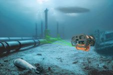
HydroSurv, a prominent provider of electric and hybrid uncrewed surface vessels (USVs), has successfully secured Innovate UK funding to advance the commercialization of an end-to-end seagrass monitoring solution. This endeavour...
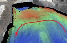
An understanding of the interplay between glaciers and the ocean is needed to improve sea-level rise projections. Seafloor mapping is critical in this pursuit, particularly where the ice sheets of...

Applanix has introduced its POSPac Cloud software for directly georeferencing data collected from cameras, Lidar, multibeam sonar and other sensors on mobile platforms. As an online version of Applanix’ GNSS-aided...
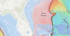
A groundbreaking study has unveiled the discovery of an immense coral reef on the bottom of the Atlantic Ocean, marking the largest deep-sea coral reef ever measured. Spanning approximately 26,000...
The esteemed Finnish Geospatial Research Institute (FGI) is set to utilize advanced Lidar systems developed by the Fraunhofer Institute for Physical Measurement Techniques IPM for future maritime surface surveys. Anticipating...
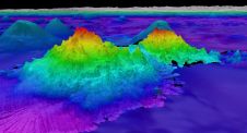
The crew of Schmidt Ocean Institute’s research vessel Falkor (too) recently discovered four underwater mountains – the tallest of which exceeds 2.4km in height – during a January transit from...
This site uses cookies. By continuing to use this website, you agree to our Cookies Policy. Agree