Mapping northern Greenland waters
An understanding of the interplay between glaciers and the ocean is needed to improve sea-level rise projections. Seafloor mapping is critical in this pursuit, particularly where the ice sheets of...
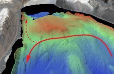
An understanding of the interplay between glaciers and the ocean is needed to improve sea-level rise projections. Seafloor mapping is critical in this pursuit, particularly where the ice sheets of...
The International Marine Contractors Association (IMCA, UK) has published new guidance on the selection of satellite positioning systems, warning that in recent years lower priority has been given to system...
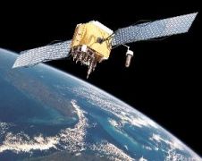
In this feature the current status and future development of four Global Navigation Satellite Systems (GNSS) are briefly presented. These four systems are the American Global Positioning System (GPS), the...
The Russian Space Forces have successfully launched a new Glonass-K navigation satellite from the Plesetsk space center, a Defense Ministry spokesman said Saturday. The previous launch under the Glonass project...
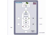
Fugro Seastar AS has announced the introduction of the MarineSTAR Manoeuvring System. The system provides a highly accurate, stable position reference for ship's bridge systems such as ECDIS. Fugro Seastar...
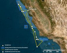
From 21 October to 11 November, NOAA Ocean Exploration is leading expeditions aboard the NOAA Ship Okeanos Explorer off the coast of central California and within the boundaries of the...

Kongsberg Discovery has embarked on an ambitious journey, commencing an extensive series of sea trials with its latest groundbreaking creation: the HUGIN Endurance autonomous underwater vehicle (AUV). Launched in 2021,...
The concept of GNSS was first introduced by the European Space Agency (ESA), the European Commission (EC) and Eurocontrol in the early nineties. They defined requirements for a European GPS...
The concept of GNSS was first introduced by the European Space Agency (ESA), the European Commission (EC) and Eurocontrol in the early nineties. They defined requirements for a European GPS...
The fourth in a series of eight modernized Global Positioning System (GPS) satellites that will deliver new capabilities to military and civilian users has been declared fully operational. Launched...
This site uses cookies. By continuing to use this website, you agree to our Cookies Policy. Agree