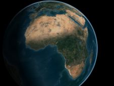
Mapping Africa's Seafloor
A two-part webinar series entitled ‘Mapping the Seafloor around Africa’ was jointly organized by the IOC-UNESCO Sub-Commission for Africa and the Adjacent Island States (IOCAFRICA) and the Nippon Foundation-GEBCO Seabed...
A two-part webinar series entitled ‘Mapping the Seafloor around Africa’ was jointly organized by the IOC-UNESCO Sub-Commission for Africa and the Adjacent Island States (IOCAFRICA) and the Nippon Foundation-GEBCO Seabed...

Seafloor Systems Inc. is a leading provider of integrated solutions for hydrographic survey applications. Our team of engineers and technicians realize the need for efficiency out in the field, and...
Oceans have their own unique soundscape. Many marine organisms, for example, use sound for echolocation, navigation or communication with conspecifics. In recent decades, however, more and more sounds caused by...

The shallow waters around islands and continental coastlines are important for human activities and for the health of many marine species. However, these areas are constantly evolving and are notoriously...
Combining the DriX uncrewed surface vehicle (USV) and the FlipiX remotely operated towed vehicle (ROTV), Exail has developed a unique solution enabling fully autonomous and remotely operated surveys. Combining the DriX uncrewed surface vehicle (USV) and the FlipiX remotely operated towed vehicle (ROTV), Exail has developed a unique solution enabling fully autonomous and remotely operated surveys. Accurate surveys...

Against the backdrop of the WWI centenary, the second edition of the Seafloor Exploration training course was conducted in Malta during the first two weeks of September. Students spent ten...
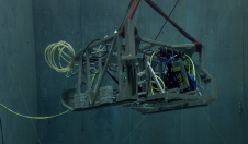
In a bid to uncover the secrets of the deep seafloor, the Monterey Bay Aquarium Research Institute (MBARI) has joined forces with 3D at Depth, a leading expert in commercial...
Airborne Lidar (Light Detecting and Ranging) is a well-established remote sensing technique which scans the terrain and seafloor with high-frequency laser pulses. Until now, bathymetric Lidar data has been processed...
IXSEA launched its new seafloor mapping solutions at 0i08. These products offer integrated solutions, which combine sonar, seismic, gradiometer and magnetometer technologies and sensors to meet the different demands of...
This site uses cookies. By continuing to use this website, you agree to our Cookies Policy. Agree